I am really looking forward to going on the Appalachian Trail (AT) with my dad. The AT is a trail that leads from Georgia to Maine and is 2,200 miles. I am going on the AT because dad asked me to and it seemed like fun. I really like the outdoors and backpacking, so I decided that I wanted to do it. I am looking forward to strengthening my relationship with my dad. I think that being on a trail together for six months is the perfect way to do that.
With Joy on Tennent Mtn.
Dad and I have been on several short hikes in the past few years. We have been to Grayson Highlands, South Mountains, Black Balsam Knob, and, most recently, to the Great Smoky Mountains. I thought that all of them were fun except the Black Balsam hike because we had to travel almost one mile down the steep side of Old Butt Knob. We were stepping and jumping from rock to rock while hoping not to fall on our own butts. Other than that they were all fun because I was bonding with my dad and strengthening our relationship. Some of the best times that I have had with my dad have been on the trail. These adventures include getting to hitchhike for the first time, as well as all the times we took the wrong trail by accident.
I am also excited about the social aspect of the trip. During thru-hiking season, the Appalachian Trail will be filled with people and I look forward to meeting these new friends and sharing stories. Spending time with other hikers could lead to establishing my tramily, or trail family, which is a group of hikers that travel together for an extended amount of time and bond by sharing fellowship and experiences.
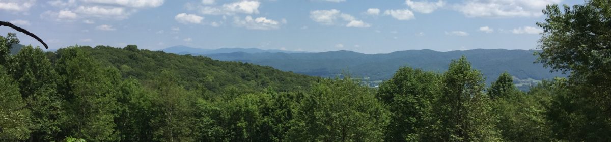
While I’m hiking, I am most looking forward to seeing wild animals and amazing views. I’m thinking of starting a nature log so that I can keep track of the things that I’ve seen. Some of the most commonly seen animals along the trail are deer, snakes, bugs, moose, and bears! If I see venomous snakes, moose, or bears, I hope it is from a safe distance. I’ve heard there are some really incredible views on the trail. I am especially looking forward to Clingman’s Dome, which is the highest point on the Appalachian Trail. I also want to experience the spectacular views from the many balds along the TN/NC border. In VA there is a cliff called Mcafee Knob, which reminds many people of the Circle of Life scene in The Lion King. I am dreading climbing Mt. Washington because it is home to some of the worst weather in the world, but if the skies are clear, it will give one of the best views on the entire trail. Most of all, I am looking forward to summiting Katahdin, the highest point in Maine, because it marks the northern end of the trail.
I could also stand to strengthen my relationship with my dad. Dad and I don’t spend all that much time doing things together and I feel like this trip will give us a chance to bond. Together, we will need to hang our food bags, cook our meals and help each other over difficult stream crossings and other obstacles on the trail. Hiking for six months together should give us many opportunities to encourage and support one another.
I look forward to staying in shelters along the trail. I love the shelters for providing cover, for their graffiti, and for their log books. The shelters are usually covered in graffiti, and it’s really interesting to read what other people have written. Most shelters have a logbook which hikers sign when they pass through. A shelter log shows you who’s ahead of you. Many describe these logs as the “Facebook of the Appalachian Trail” because some people leave messages for other people in them.
These are all reasons I am looking forward to going on the trail with my dad. From the views, to the animals, and the many experiences we will have, I eagerly await each one. I am looking forward to our future endeavors. I love that we are going to get to spend so much time together and I’m looking forward to my future blog posts. I’m really excited about this trip and the time I will spend bonding with my dad. Thank you for taking time out of your day to read this entry. We really enjoy hearing your feedback. If you’re new to our site, please check out our other posts, and consider subscribing.
Trails Traveled: Little Cataloochee Trail, Pretty Hollow Gap Trail, Balsam Mtn. Rd., Balsam Mtn. Trail, Mount Sterling Ridge Trail, Mount Sterling Trail, Long Bunk Trail, Little Cataloochee Trail.
Day 1: 6.8 miles, 1,358 ft elevation gain
This week we completed a trip that I had planned for a few weeks ago, but it was postponed because of single-digit temperatures, snow, and rain. I’m glad we waited. Our original plan had been for a four-day, three-night trip to help us test out our gear for cold weather. I’d have to rate the trip as an unqualified success on many levels.
The first day we didn’t get away from home until around noon, which put us at the trailhead around 3:00. I don’t know what it is about getting our stuff together, but that is one area we have for improvement. I had planned to experiment with an ultralight pack I borrowed from my friend Paul. Unfortunately, Paul’s pack is a 58-liter bag and apparently, I have 65L worth of bulk and gear. As I’ve mentioned before, pack weight is of primary concern when planning a long-distance hike and I’m exploring all options to get my weight down. This is going to get a little geeky, but my current pack, an Osprey Atmos 65AG weighs 4lb-10oz. The pack I’m researching weighs in at just two pounds. That is a significant savings, but I really wanted to test one before dropping the cash for a new pack.
I realize that I successfully escaped from my original topic sentence: we left late. Our trip to the GSMNP was two hours down I-40 and then 45 minutes (12 miles???) on narrow, winding one to one-and-a-half lane roads. Silly me, but I was expecting a parking lot at the trailhead. NOT. We were greeted with a wide spot in the road and a sign admonishing us to not block the gate. I let Gavin out and I pulled the truck up with the passenger side as close to the side of the shoulder of the road as I could. On the way into the park, we noticed a dusting of snow on the roads and the ground nearby and I hoped we hadn’t gotten in over our heads. The night before our trip, the forecast for Mount Sterling was for 4°F temperatures with a wind chill warning. It was probably in the mid-30’s when we set out on the trail and we expected it to dip into the low 20’s the first night out. The two redeeming highlights of our trip to the trailhead were finding Bigfoot (you’re welcome, Josh), and seeing an elk! You must check out the video to see this beautiful creature. I’m not sure I’ve ever seen one before and he cooperated by just grazing along while we pulled the truck up alongside. We must have sat there gawking and videoing for 5 minutes before driving on to the trailhead.
Before continuing, allow me to tell you a few things about the Great Smoky Mtn. National Park. First, I’ve read that it is the most visited National Park in the US, but we only saw three people on our 3-day trip. I guess we should have come in warmer weather. Miles and miles of trails crisscross the park, and the Appalachian Trail traverses 71 miles through the GSMNP. The park is truly kept as a wilderness area and to this end, camping is only allowed at designated campsites and shelters, and only then by reservation. Before heading out, we visited the GSMNP website and planned out our trip for three nights: campsite 39, Laurel Gap Shelter, and finally at campsite 38 on top of Mount Spencer. The camping restriction means that no matter how tired you get along the trail, you must press on to get to your scheduled site or risk being ticketed and put out of the park. Another important fact about GSMNP is that it is home to a huge population of black bears, which Gavin and I have already experienced one too many times. Fortunately, all of the campsites and shelters in the park are rigged with ¼ inch steel cables on pulley systems to hoist your food and other smellables out of reach of hungry bears. These contraptions certainly take the guesswork out of having to hang a bear bag and take the weight out of having to carry a bear canister.
For our first afternoon, we had planned a hike of a little less than seven miles to campsite 39. At a 30-minute mile pace, it would put us pushing 7:00 to get there. Our late start lead me to think about bunking in Asheville and pushing the trip off for a day, but alas, our reservation at campsite 39 was for Wednesday night so we had to make the best of it.
The trail today was truly beautiful. We started off walking up a gravel road, which was slightly graded. The only real obstacle was a 3-foot tree that had blown down. The trunk and giant tangle of limbs made it quite difficult to traverse, especially for Gavin. All afternoon we crossed back and forth over and then paralleled streams and creaks. In looking over my video footage this afternoon, it looks like the only thing I recorded was streams and ice. About two miles in, we came to an old log cabin. We both went in and looked around a bit, but I don’t think either of us went upstairs. I was slightly worried that my weight and the stability of the floor might not jive. A bit later on up the trail, we unexpectedly came to a second cabin that was surrounded by a split-rail fence. If the chinking in the logs had been kept up and if it were a little closer to Walmart, I could have lived there. Unfortunately, we didn’t explore this one because it was getting a bit late and I felt it necessary move farther along before darkness fell.
And darkness did fall. I have read about AT hikers voluntarily night-hiking to catch up with friends or to make it to a certain place to view a nice sunrise (i.e. Max Patch or Roan Mtn.), but I have read nothing about having to night hike because you’re not allowed to just drop a tent wherever you want before darkness sets in. I must say, though, we did pretty well with it. My headlamp was buried in the depths of my pack, but Gavin’s was on top, so he donned his and lead the way. Maybe his trail name will be Rudolph! With me close on his heels, paying careful attention to the rocks he was tripping over in order to avoid the same peril, we plowed on. Until, that is, we reached a stream crossing with 3-ft stumps creating a parkour-like, hoppity-skip across. Did I mention that most of my videos were about streams and the ice therein? Usually I wouldn’t have worried about this crossing, which was, in fact, one of the best I’ve seen, but the only thing I could think of in approaching it was the skim of ice on the logs, the dusk, and how cold the water would be when one of us landed on our butts in it and froze off some valuable appendages. Needless to say, since I’m typing this with a full compliment of fingers, we made it across.
The first day’s hike was a 3-mile up followed by a 1.75-mile down, and ending at the campsite with a slight uphill climb. After nearly 7 miles, the final climb was arduous and we like to never have found the campsite, but eventually, we did. We had plenty of water to make supper (Idahoan Loaded Mashed Potato Soup and Spam – we recommend it) and brush our teeth (or at least I did) before settling down to bed. One of the goals of this trip was to be sure we had the gear to hike and sleep warmly. For hiking, I donned a long-sleeved Capilene base layer topped with my rain shell and my convertible hiking pants (legs off.) I had no problems at all with this setup. When we got to camp, though, I switched to my woolen long johns and dry wool socks. I topped this off with a down jacket for warmth and my rain shell to block the wind. Gavin dressed similarly, except that he hiked in nylon sweat pants. It is important to have dry clothing in camp after hiking because even in winter one will sweat and you don’t want to be sitting still in wet clothing or hypothermia will set in. This was our first experience with winter backpacking, and I believe we passed the test.
The temperature dropped to the low-20’s Wednesday night and we both slept warmly. We both have sleeping bag liners which are supposed to add 10-15° of warmth to the temperature rating of the bag. I loaded up my bag with my damp hiking socks and shirt, water bottle, electronics, and most importantly, our water filter to keep each item from being frozen solid in the morning. Unfortunately, I neglected to tell Gavin that is was supposed to be as cold as a witches protuberance in a brass foundation garment, so what was left of his water froze. Fortunately, we were camped right next to one of the many creeks we saw, so getting and filtering water was not an issue.
Warning: This paragraph is not for the feint of heart. A lesson that one has to learn when embarking on a trip into the wilderness is how to responsibly answer the call of nature. For this part of my hiking experience, I still need to do a bit of research. I understand the part about digging the 6-8” deep cathole into which one deposits and buries one’s waste, but the directions I’ve read are a bit unclear about how one should manage this when dealing with frozen soil and roots that won’t give in to the 0.6-ounce, aluminum deuce of spades (seriously, that is the name of the piece of gear.) I will say that some duct tape wrapping on the handle of this lightweight tool is necessary to prevent blisters of the palm created by digging. I’ll keep you posted on this front. I must also remark that I didn’t think about the wet wipes in the top of my pack freezing during the night, but they did. Thankfully, they were packed in a plastic bag, so I was able to boil a little water and soak them enough to get one loose. Happy Day! Even when they were babies, Gavin and Griffin didn’t get warmed baby wipes!
Day 2: 8.8 miles, 3,038 ft. elevation gain
I knew that day two would be our most difficult day of hiking. Looking at the elevation profile of the trail, it was nearly all uphill for 8+ miles. To put it bluntly, I have discovered that I suck at uphills. Literally. I walk 30 feet, pause for a minute or two leaning on my trekking poles and suck wind! Holy cow, I had no idea I was in such bad shape. I’m aware that I have gained back more than twenty pounds in the past year or so, but I had no idea that it would affect my hiking in this way. As poorly as I hiked today, I see now that I have no choice other than to go to the basement and go to town on the step-mutha and treadmill housed there. I’ll probably even have to start hiking the horrendous vertical mile trail at Rocky Face. I really don’t want to do either of those things, but unfortunately, I believe they’re necessary. Mamaaaaa!
As has become our unfortunate habit, we slept in. Remarkably, Gavin was up before I was. He was in the process of making his breakfast when I rolled out (embarrassingly) at 9:45. We ate, organized, and packed and got on the trail about noon. Seriously, we’ve got to work on this or we’ll never make it out of Tennessee before late summer. The most remarkable thing about Thursday’s hike is that it started raining about 30 minutes after we started hiking. Thankfully, it never rained hard and it was much warmer than Wednesday so I was able to go in shorts, long sleeves, and my rain shell. This was the first real test of my new rain shell and it passed with flying colors.
After miles of uphills that nearly brought me to tears, our second day ended, finally, at the Laurel Gap Shelter. I have walked past many and have stayed in a few AT shelters and this one put them to shame. I guess GSMNP puts the money from hiking/camping permits back into the amenities of the park. This shelter was a 3-sided rock structure measuring about 10’ x 20’ or so. Over on one side, there was a fireplace, and the front was covered by a huge plastic tarp to block the wind. Inside there were two levels of sleeping platforms as well as some benches for sitting. Outside was a covered porch area that had benches to sit on and tables to cook/eat on. It was by far the nicest shelter I’ve ever seen. Gavin and I had the whole place to ourselves. Unbeknownst to me, Gavin had hoped that I would sleep on the top-level sleeping platform so he’d have some plywood blocking him from my snoring. Oops. I cannot overstate how glad we were to be in a shelter Thursday night. As the night wound on, the misty mess we’d hiked in all day turned into a full-fledged rainstorm that continued on all night. Though I’m confident that I’d be dry in my tent, it was really great not to have to mess with packing up wet in the morning. It was also much easier to get situated for the next day’s hike sitting on a nice dry platform to dress for the day.
Day 3: 14.4 miles, 1,378 ft. elevation gain
Friday was to be our easiest day of hiking. According to the map, we’d have a fairly flat trek of only 5.7 miles along the Mount Sterling Ridge Trail to campsite 38. Knowing this, and again, because we’re not morning people, we didn’t rush to leave the shelter. Gavin had a dry breakfast of something, but I took time to boil water for coffee and oatmeal. Folgers makes these little coffee teabags that taste remarkably like brewed coffee. I did splurge and bring some single-serve creamers, but I didn’t bring sugar. Hoping for a little more protein than is offered up by oatmeal, I wound up mixing some chocolate instant breakfast mix with my coffee and it was remarkably good. Caffeine and protein are incredibly important for hiking.
We set out from the shelter around our normal time of noonish, knowing that we didn’t have far to go to our campsite for the evening. Unfortunately, the rain didn’t stop to accommodate us. We departed in our hiking clothes covered up in rain pants and shells. One of the things I’ve read about rainwear is that nothing is waterproof for more than 30 minutes or so. Even though most “waterproof” fabrics claim to be breathable, they don’t breathe as hard or fast as I do on an uphill section. Thus, even though you may not get wet from the rain, you will be doused from the inside with sweat. Truthfully though, I stayed comfortable and warm. I’m not even sure I was aware I was wet except for the times when we stopped for a few minutes and I began to feel cold.
As I mentioned above, this nearly 6-mile ridge walk was to be our easiest day of hiking, which got me to thinking. For me, thinking is often dangerous. According to our map, the final day of hiking on Saturday was going to be almost all downhill with sections of flat. Humm… wouldn’t it be great to sleep indoors tonight? I figured we could get to the car a little after dark and head into the Hampton Inn in Asheville for the night. I already had visions of setting my tent up on the bed and FaceTiming Beth and Griffin from inside and then unzipping the tent and stepping out into a hotel room. On our way across the ridge, actually, it was on one of the few uphills of the day when Gavin and I were leaning on our poles panting, a young couple passed us. They were headed to campsite 39, and Gavin wanted to camp there and visit with them overnight. I told him that we’d make the final decision when we reached the trail crossing that would take us back to the truck. When we finally reached the crossing about 0.5 miles from the campsite, I used fatherly coercion to convince Gavin that warm bed wins over wet tent every time. Though he was against it, he grudgingly agreed to hike on down to the car. When I say he hiked, he really hiked. He took the lead and set the pace for sub-30 minute miles for most of the way down. I am so proud of him! He is a strong hiker and an encouraging partner and I look forward to our 2,200-mile journey together.
That is how our 6-mile hike turned into 14.4 miles. The rains didn’t let up, but we were spurred on by the thought of a warm shower and a comfy bed. Fortunately, the trail cooperated with us. As promised, the trail was nearly all downhill, wrapping back and forth around the bases of mountains. The most difficult part of the hike was crossing the many streams, strengthened by the rains that formed anywhere two mountains came together. Many would have been intermittent streams in dryer weather, so there weren’t carefully placed rocks in most places to step over. In the end, though, it didn’t matter much. Much of the day’s hiking had been over a trail that crossed through tons of swampy, sloggy, muddy muck. Early in the day, I gave up on trying to keep my shoes dry. Thankfully, the waterproof lining in my shoes held up pretty well so we plowed on.
I say the stream crossings were the most difficult part of the day’s hike, but actually, I believe the trail stretched on us as we hiked. What I calculated to be nearly 12 miles turned into 14.4 by the GPS. I’m not sure how that happened because I know that we didn’t wander around in circles for nearly 2.5 miles. Needless to say, we wound up night-hiking again. Finally, right at 7:00 we reached the truck. Glory Be! After loading up and getting out of our rain gear, I calculated that it would be around 8:30 before we could make it to the hotel in Asheville. That time wouldn’t factor in showering and going to eat. More calculation showed that we could be home by 10:30-11:00, and that would include a hamburger supper somewhere along the way. This was the option we chose, and Beth and Griffin even waited up on us (we sent a selfie from Burger King to alert them of our coming.) If you know Beth, staying up until 11:00 was an even greater accomplishment than our long day of hiking.
In closing, there were several goals that we hoped to accomplish with this trip. Cold-weather camping: check – Put the water and filter in your sleeping bag, and you’re good. Hiking in the rain: check – Our rain shells keep most of the weather at bay, or at least they kept us warm. Unintended goal of night-hiking: check – “Rudolph” is on it. Second unintended goal of long-distance hiking: check – as long as it is downhill. The final goal of setting/packing a tent in the rain: okay, I wimped out on this one, but I’m sure we’ll have plenty of opportunities in the future!
Congratulations on making it to the bottom of this post! I cannot tell you how much I appreciate you for reading our blog and sending comments. I know that when we start the trail in February, it will be the kind words and encouragement from family and friends that will keep us going. If you’re interested, please subscribe to our blog and/or YouTube channel to get email updates of our travels. Several folks have asked how to find the YouTube channel and truthfully, the simplest way is to follow a link out from here and then subscribe. Apparently, there is a popular dance group or TV show by the name of “Next Step,” so we’re dang near impossible to find by searching from within YouTube. Again, thanks for reading and check back soon!


 The two redeeming highlights of our trip to the trailhead were finding Bigfoot (you’re welcome, Josh), and seeing an elk! You must check out the video to see this beautiful creature. I’m not sure I’ve ever seen one before and he cooperated by just grazing along while we pulled the truck up alongside. We must have sat there gawking and videoing for 5 minutes before driving on to the trailhead.
 A bit later on up the trail, we unexpectedly came to a second cabin that was surrounded by a split-rail fence. If the chinking in the logs had been kept up and if it were a little closer to Walmart, I could have lived there. Unfortunately, we didn’t explore this one because it was getting a bit late and I felt it necessary move farther along before darkness fell.
 Until, that is, we reached a stream crossing with 3-ft stumps creating a parkour-like, hoppity-skip across. Did I mention that most of my videos were about streams and the ice therein? Usually I wouldn’t have worried about this crossing, which was, in fact, one of the best I’ve seen, but the only thing I could think of in approaching it was the skim of ice on the logs, the dusk, and how cold the water would be when one of us landed on our butts in it and froze off some valuable appendages. Needless to say, since I’m typing this with a full compliment of fingers, we made it across.
 Unfortunately, the rain didn’t stop to accommodate us. We departed in our hiking clothes covered up in rain pants and shells. One of the things I’ve read about rainwear is that nothing is waterproof for more than 30 minutes or so. Even though most “waterproof” fabrics claim to be breathable, they don’t breathe as hard or fast as I do on an uphill section. Thus, even though you may not get wet from the rain, you will be doused from the inside with sweat. Truthfully though, I stayed comfortable and warm. I’m not even sure I was aware I was wet except for the times when we stopped for a few minutes and I began to feel cold.