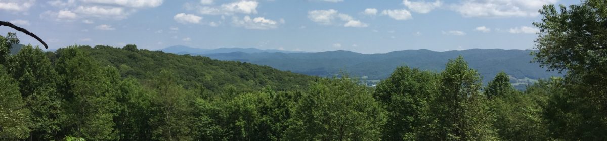
My Scout leaders and I took 9 boys on a backpacking trip Wednesday thru Friday to the Grayson Highlands State Park area of Virginia. It took us only about an hour and fourth-five minutes to get there. It is a fairly easy drive and the park has incredible views. There are tons of day hikes that aren’t too difficult. It is certainly worth the trip to visit.
Before getting into a day-by-day description of the trip, I want to thank Danielle, Melanie, and JT for coming along. It was the ladies first backpacking experience, and they did great! We sort of split off into two hiking groups. Gavin and Joy lead the way, and I did my best to keep up with them and some of the faster scouts. JT brought up the rear to make sure nobody got left behind. It really worked out well. The front group did a good job stopping every little while so the second group could catch up. After socializing a bit, the lead group would break off and head on down the trail. I was really proud of the whole crew, as we hiked at a pace of 2 mph, not counting rest breaks. This was pretty close to what I thought we’d do.
Day 1: July 18
We left Bethlehem heading north, and after a brief stop at Cook Out in Wilkesboro, we headed on up Hwy. 16 into Virginia. We got on the trail a little after 5:00, hiking from the backpacker parking lot up to Massey Gap. We joined the Appalachian Trail heading north to the Wise shelter area. No camping is allowed in the area just around the shelter, so we crossed Big Wilson Creek to be just outside the state park boundaries before making camp. Most of the boys were hammock camping, and there were plenty of trees available. Everyone had a great supper and I’d like to say “settled in for the night,” but that was just the adults. The boys were restless and told jokes like you’d expect middle school boys to tell. Eventually everyone got a good nights rest.

Day 2: July 19
This was the most difficult day of the trail. We started out going up, and continued doing so for most of the day, though there were some level areas and a few downhills. The hike wasn’t difficult, but it was a long day of about 6.5 miles with almost 1,100 feet of elevation gain. The hike was highlighted by many nice views, as well as the sighting of a couple of deer and several of the famous Grayson Highlands wild ponies. We even got to watch one take a mud bath on the trail. I thought only dogs did that.
We stopped to eat lunch and “sit down” at the Scales, an old livestock corral. There is a two-room privy and there was supposed to be a spring, but we never did find it. After leaving the Scales, we also left the AT, heading along the Crest Trail. This was essentially a one-lane gravel/rock/boulder road and horse path. It wasn’t tough hiking, but I could have done with fewer rocks. The highlight of the day was passing by the campground because it wasn’t where I thought me map said it should be. I insisted on going several tenths of a mile farther in search of the “real site.” The lead group finally stopped and dropped their packs and I headed on ahead alone looking for the site, but after 0.5 miles or so, I realized that the kids were right, and that we had passed the site (sorry guys, I was wrong!) We headed back the way we came and set up camp for the night. The first order of business was searching for the water source that I had been told about. After a text and a phone call to a friend, we still didn’t find it, so I headed down the trail to see if I could find a usable spring close by. I did manage to dig out a place to get some water, but it was pretty murky. Then I heard someone shout, “We found it!” Funny thing is, we had all walked past the spring which was protected from the horses and cattle by a split rail fence. Duh. 0 for 2 today, I guess.
We had beautiful views from the campsite, but we also got colder than expected temperatures. We had been forecast for 60°, but I think it was closer to 55°, and on the ridge there was definitely some wind chill in play. The boys had a good time exploring the area and climbing on rocks, but the adults were freezing. I tried going in my tent to get out of the wind, which was nice, but Joy was whimpering because she had been abandoned. I zipped the legs on my pants and got back out of the tent to read and play with her for as long as I could stand it. About 8:30, I called all the boys in and suggested that they should hop in their hammocks and settle in and warm up. I’m pretty sure I was asleep before the sun set completely.

Day 3: July 20
We started breaking camp around 7:45. Actually, it may have been earlier for some, but I don’t respond well to alarms and tend to hit the snooze button multiple times. As we were packing up and having breakfast, JT told us that he had a bear sniffing at his hammock during the night. The boys found some footprints, but I was too focused on making coffee to go look. I wish I had. Just as we were about to pack out, a herd of 5-6 ponies galloped through what had just minutes ago been our campsite. They stopped in the clearing and hung out for a while. Two of them even went over and inspected my pack. This was our closest and best pony encounter of the trip.
The hiking this day started out with a steady uphill climb. Did I mention that yesterday there were rocks? Never mind. Today, there were ROCKS! The trip down the mountain was treacherous! Looking back, I realize that I had been concentrating so much about maintaining my footing that I hadn’t taken any pictures of the terrain we were traversing. On the way down we met up with 76-year-old Pathfinder, a NOBO thru-hiker who started the trail at Springer Mtn. on March 23. She was struggling with a bum knee and was trying to navigate the descent. Another hiker had already taken her pack to the bottom of the most difficult area. I sent the boys on and hiked with her for the next hour or so. Her knee had reduced her pace to a crawl, especially trying to navigate the huge rocks and steps going downward. She had treking poles, but I took one or both of her hands to help her down some really difficult parts of the trail. We had a lovely conversation, and I told her that Gavin and I were planning to start our thru-hike in February or early March. She was insistent that it was too cold in February, and that we should wait. She also said that she’s probably the last NOBO thru-hiker going up the trail this year, and she is probably right. She had to miss the Smokies because of a fall that resulted in a dozen stitches in her forehead. She was adamant that she would have to come back and do that part of the trail later on. We were met by a local not far from where the trail difficulty eased up a ways, and she hiked the rest of the way into Massie Gap with Pathfinder. I hope that she was able to get her knee iced and looked at, and that she is back on the trail heading North.

Our trip this week was truly a marvelous experience, for both the young and the older. I appreciate Paul for suggesting this route as our first backpacking excursion since I’ve been with the troop, and for trying to help us find water at our night two campsite. The boys are already talking about going on another trip like this one as soon as we can. I know that I am ready. I believe this trip, especially meeting Pathfinder, made me more ready than ever to get out on the trail. I can’t wait to start!
Be sure to check out the photos of this experience, which are linked in the menu above.


