Days 26-30

Our first day out this week was a short one, but don’t think we didn’t have a tough hike. We started on Thursday morning by getting a shuttle from The Lodge at Fontana Village back down to Fontana Dam. Needless to say, when you start at water level, about the only way to go is up. We had a 6-mile, 2,o00 foot climb to our campsite at Birch Spring Gap. The first mile or so was across the dam and up a roadway where the trail broke off and we entered the Great Smokey Mountains National Park. Just a few feet up the trail there is a box where thru-hikers are supposed to drop one part of their permit before entering the park. As we were doing that, we met a ranger who told us the weather would be so-so for the day. He was right. Part of the day was nice, but once we started climbing, we began to experience sleet and freezing rain. It wasn’t enough to be annoying, but it was one of our first experiences in dealing with frozen precipitation. I suppose the greatest disappointment of the day was not taking the 0.1 mile side trail to the fire tower at Shuckstack. Ordinarily, we would have certainly done it, but by the time we got up there, the weather had us pretty much completely socked in so there would have been no views to warrant the side trip.

After an arduous 6-mile uphill trek, we arrived at Birch Spring Gap campsite. I am thankful that Travis noticed it in the guidebook, because our original plan had us going 11+ miles to Mollie’s Ridge Shelter. That would have made for a very long day. It turns out that Gavin and I were a significant majority in the campsite. Travis, of course, is from Canada. The gentleman staying right beside us hailed from Ireland, and across the valley were two guys from Isle of Man. If nothing else, Gavin has had more exposure to folks from other countries than he would have ever experienced in our small hometown.

After pitching our tents, Gavin went to the campfire ring to start a fire. I was really proud of him. He was able to find some poplar bark which he worked into tinder, and we had plenty of twigs that were dry enough to catch. Though the poplar bark was a little damp, once he got some spark into it, he was able to blow it into enough flame to light the kindling. Before long, he had a roaring fire going to keep us warm. That chore complete, we began our cooking process. It isn’t much of a process. Dump a package of Knor Pasta/Rice into a pot, put in a little water, boil it, and wait. At the precise moment when I was sure the pasta had soaked enough to be edible, a sleet storm set in. Within just a few minutes, there was enough sleet to whiten the ground and put out our cozy fire. We quickly finished our supper and retreated to our tents. Thanks be, the storm didn’t last too long. We were able to knock the sleet off our tents and Gavin went around the campsite collecting it to make little snowmen. They really were quite cute. He made sure to take one across the valley to Travis, and offered to make them for other campers. The ability to be creative probably saved the day for Gavin because the unexpected frozen weather caught him a bit off guard.

One of the things I really enjoy is the solitude of my tent. Mostly, I suppose, because I can get all my stuff spread out so that I don’t have to search around for things— everything has its spot. First, I toss in my sitting pad so my tush doesn’t get cold sitting on the ground. Next step, blow up the sleeping pad and get it situated diagonally in the tent so neither my head nor feet are touching a wall. On top of that goes my sleeping bag, opened. If it is cold, I’ll also get my sleeping bag liner in place. My pillow gets blown up (3 breaths, I’ve counted) and tucked into the hood of my bag. From there, I can lay back, swap my hiking pants and shirt for wool long underwear, and switch my hiking socks to camp socks. The damp, smelly hiking socks, and sometimes my hiking shirt, get hung up to dry on a line stretching across the inside roof of my tent. Eventually my pants and shirt get stuffed into the bottom of my sleeping bag so they are warm the next morning when I go to put them on. All my extra stuff, clothing bag, electronics bag, meds, and such all get tucked away in the top corner of the tent so they are out of the way of the door, but easily in reach from my sleeping space. I haven’t quite worked out the etiquette of changing clothing in a shelter when there are women present, so for the time being, I am appreciative of my tent for such purposes. It is also a bit less smelly than changing in a privy (if one is even available).

So it was on Thursday night. I was snug in my tent, and even though the temperature was below freezing, I slept warmly in my cocoon-like sleeping bag. When I woke, my high/low thermometer indicated that the temperature only got down to the high 20’s overnight.

Friday wasn’t a terrifically tough day of hiking, but for whatever reason, I just wasn’t “feeling it” that day. We completed an 8.5 mile trip, mostly uphill, to the Russell Field Shelter. In looking back at my photos, it doesn’t seem that there was anything much remarkable about the day’s trip. I do remember that we stopped at Mollie’s Ridge Shelter for lunch and met a few hikers we have seen before, and that I just wasn’t as into hiking this day as I usually am. We stayed the night at Russell Field shelter.

Russell Field Shelter was our first shelter in the Smokies. It was constructed in almost the same manner as was the one we stayed in on our December training hike. Rock walls, two sleeping levels, fire place in the front corner, and a tarp spread across the front to keep the wind out. It was packed. By the time we got there, the only spaces left were on the top level. There is a small ladder in the center that gets you up there, but if you’re off to one side of it, getting down in the middle of the night for whatever reason is quite a long step down to the platform below. Thankfully, I was able to sleep through the night.

Shelters are different from tenting in that I don’t feel good about taking up too much space. Also, you’re sleeping within a foot or two of someone you dohn’t know, and I am often conscientious of taking up too much room and snoring. And there is the whole changing clothes thing. Though I slept well enough, most of us older hikers would much prefer to set up our tents and leave the shelter life to the younger crowd.

You might be wondering why I chose to stay in the shelter at Russell Field instead of putting up my tent. It wasn’t really a choice. In the Smokies, you are not allowed to tent at shelter areas unless there is no room in the shelter. You must also stay at a designated shelter area or campsite. It was kind of funny when we arrived to see all the folks outside counting heads hoping the shelter would fill up so they could legally pitch their tents.

One benefit of staying in a shelter is not having to pack up your tent in the morning. That time saved gets you hiking a bit earlier in the day. Throughout my trip, I have been setting an 8:00 alarm and religiously hitting the snooze button for 45 minutes to an hour. When you’re in the shelter, you start hearing all the folks moving around pretty early. Some hikers are adamant about getting up with the sun and hiking out at daybreak so they can get their miles in. I’m certainly not there yet. I have noticed this week, though, that I am beginning to wake up without my alarm going off. Maybe that means I’m becoming acclimated to a hiker’s lifestyle.

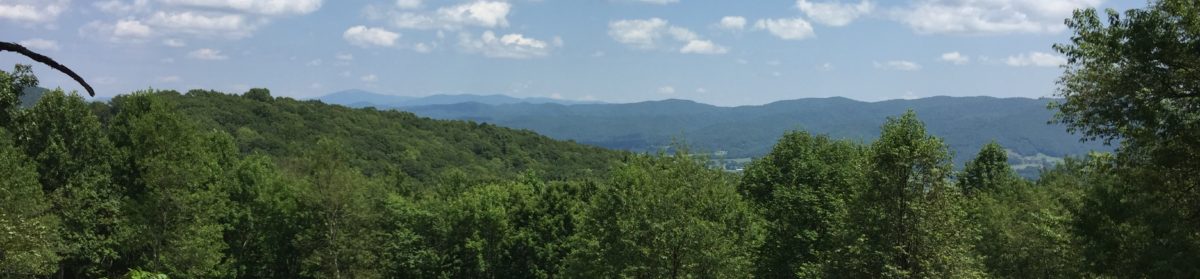
Saturday was one of our best days of hiking yet. Because we sheltered, we were out somewhat earlier than usual and we had great weather. Though we had some tough climbs, most of the hiking was not too difficult. The highlight of the day was reaching the peaks of Rocky Top and Thunderhead Mtns. I tried to sing the song, but the view was simply breathtaking. We had perfectly clear, blue sky and we could see in all directions. We also had more views from the trail than we have had in any other section of our trip. I wish I could tell you more about this day, but the views were simply indescribable. You’ll have to check out the video when it comes out.

We covered 9 miles on Saturday, one of our best days yet. We are beginning to feel like we can and should be doing more miles each day. We are getting stronger, though the uphill climbs still tax me. I have made a pretty good go of following another hiker’s advice: never walk faster than you can without having to stop. Sometimes this means a heel-toe slog, but as long as we’re not having to step over rocks or water bars, I can usually get into a slow, steady rhythm with my hiking poles and continue moving forward.

We stopped at Derrick Knob Shelter on Saturday. This will remain a memorable stay for several reasons. First, it was sunny and clear when we arrived, and there were tons of folks just laid out in the grass in front of the shelter eating, stretching, or just snoozing a bit after a hard day. Come to find out, many of those folks were counting heads, waiting on the shelter to fill up so they could tent. The shelter never filled to capacity, but several of them tented anyway.

The other memorable part of this day is two-fold. First, I passed a hiker while going uphill AND I stayed in front of him. Second, was the snoring of that hiker in the shelter that evening. Though I was able to get to sleep, and when I do, not much will wake me, it was a challenge that night. The man who was “sleeping” beside me eventually got up and set up his tent in the dark to escape the noise. Though I slept through the snoring, I did toss and turn quite a bit in the night. When I woke up, my sleeping pad was cockeyed to the way I put it down earlier.

Our longest day of hiking to date was on Sunday. Originally, we had planned to hike only six miles to another shelter, but knowing that Clingman’s Dome was within our reach, and that it would likely be raining on Monday, we decided to push out 13 miles to Mt. Collins Shelter. This was without a doubt the prettiest section of trail so far. Much of the trip was through a coniferous forest with spruce and fir trees. The forest bed was green with moss and ferns. When the wind blew, it smelled like Christmas. There was one part along the trail where I just stopped and cried as I took in the beauty of God’s creation. I don’t think I will ever forget the terrain we traversed that day.

We made it to Clingman’s Dome which is the highest peak on the whole Appalachian Trail. Clingman’s Dome also happens to be the 200-mile mark for NOBO hikers. Though our views weren’t perfect, from the viewing platform we could see quite a ways nonetheless.

The trip down from Clingman’s Dome was challenging at times. Though we had come up through spots where the trail and ground nearby was snow-covered in parts, much of the trip down was over packed snow and some ice. Thankfully, the temperature was warm enough that the frozen stuff on the trail was mostly slush and we could traverse it without slipping. Mt. Collins Shelter was about 0.5 mile off the trail and it was without a doubt the busiest shelter area we have come across yet. Filled to its capacity of 12-15 folks, there were as many tents set up in the area around the shelter. Gavin and I found a couple of flat spots under the spruce trees to set up. Needless to say, after a 13+ mile day, we slept very soundly.

That brings us up to today. We slept in a little bit because of our long day yesterday and because we had a short day today. From the shelter it was just five miles to Newfound Gap, on the TN/NC border. Travis got out ahead of us, as is usual, and Gavin and I hiked together. This week we have been hiking with me in front, so that I can hike my own pace, but every so often I will stop and let Gavin catch up, or at least get within sight. With my longer legs, I have a tendency to walk up on top of him when he is in front, so this new hiking order seems to be working well for both of us. Neither of us had a wonderful breakfast so we didn’t feel our best, but we covered the five miles in just over two hours, our fastest pace yet. It is good to have learned this week that we can hike longer distances and that we are getting faster.

There is a saying that “The trail provides.” This was especially true today. When I reached the parking lot at Newfound Gap, a guy in the first truck I passed offered me a Gatorade. A lady in the second car I passed said, “Do you need a free ride to Gatlinburg?” She dropped us at the NOC, an outfitter here and we started looking for a hotel room for the next two nights. We called one place which caters to hikers that was listed in our trail guide, but they only had rooms for one night. We asked around and some other hikers we met were staying at the Motel 6. When we called, the rooms were reasonable so we walked a few blocks over. The deal-breaker was, they had no laundry facilities. On the way back downhill we stopped in the next “hiker-looking” motel, only to learn that they only rent by the week. On a lark, we stopped at the Sure Stay Plus by Best Western. This hotel is usually $200+/night, but we got the hiker rate of $50/night and the desk clerk told us that there was a laundry room at the dive of a place we just left. To top that off, Texas Roadhouse was only two blocks away. Steak and ribs, loaded baked potato, salad with blue cheese, and a tall, cold drink, please. Today has really been an awesome day, especially since nobody at the week-at-the-time place stole our clothes. Oh, and to top it off, one of the residents gave us her last cup of laundry detergent. It has truly been a good last few days, but today has been the cherry on top!

We haven’t looked ahead much to the remainder of the week, but I expect it will involve hiking, and probably uphill. The northern end of the GSMNP is at mile 238, Davenport Gap. If we keep our pace of the last couple of days, we should be able to do that in 3 1/2 days or so. I’m not sure if that is our next resupply or not, but we’ll check back in when we have WiFi. As always, we really appreciate you for following our blog. Thanks for your comments and remember to just keep taking the Next Step.

Days 22-25

On Sunday, we got a ride back to the Nantahala Outdoor Center from Beth and Griffin. Beth, Travis, and I had a nice lunch together in the restaurant by the water while Gavin and Griffin ate outside with Joy. I think it is great how well Beth and Travis got along, and she has reached out to his wife on Facebook. After lunch, we visited the outfitter onsite. Gavin and I were looking for a supplemental water filter that would work faster at stream crossings on the trail. I really love my 4L Platypus Gravity Filter, but it is a bit slow if we just need to get a liter or two on the trail. Fortunately, we were able to find just what we were looking for, and Travis got one as well. After a quick trip to the potty (unfortunately, the plastic, lined-up-in-a-row variety) we were ready to say our goodbyes and head up the trail/back up the road.

The hike out of the NOC was a uphill slog of almost 3,000 feet. Thankfully, most of the climbs in the south are graded with switchbacks. You walk up a more gentle grade for a ways, and then you turn 180° and continue walking onward and upward. Not only is this good for hikers, making the uphills less difficult, it is also a good way to control erosion along the trail. If the trail just went straight up, when it rains, the water would run straight down, bringing the mountain down with it.

Our destination for the evening was Sassafras Gap Shelter, 6.9 miles away. Along the way, we passed a monument to Wade Sutton, an NC Forest Service Ranger who died fighting a forest fire nearby in 1968. The monument was festooned with loose change, rocks, and other trinkets. This will not be the only such monument we will pass as we make our way to Maine. We made it to the shelter and met a few new hikers including a pleasant lady called Pushing 60. The shelter was situated so that the “cooking platform” had benches that allowed us to look out of the shelter and down into the valley below. Gavin and I both stayed in the shelter because there were so few people there that night. It was good to not have to hassle with pitching my tent.

The next day we set out for Brown Fork Gap Shelter. This was our longest day of hiking in quite a while, at 9.1 miles. Thankfully, most all the day was spent hiking in and around the bases of mountains with easy terrain. The climbs were few and gentle UNTIL…. Near the end of the day, when we were almost spent, we started a section of the trail called Jacob’s Ladder. This was a section we had been warned about early on by Santa from Atlanta. It was a tail-kicker. Never mind the switchbacks. It went straight up. And up. And then up some more. Just when we thought we were about to reach the top (silly us), it went up even more. This was hands-down the most difficult and vertical climb we have made, even considering the haul up Albert Mountain. I hope we don’t have to deal with anything like that again until New Hampshire.

When we got to the shelter, there was not much room left. Gavin was able to secure a spot, but I wound up walking down into a valley beside the shelter to find ground flat enough to pitch a tent. Thankfully, this spot was near the water source. Before I bedded down, there were two more tents pitched beside mine. It was at this shelter that I was able to catch my first marvelous sunset. It was truly phenomenal. The temperature dropped to the 20’s, but we all slept warmly.

By the time I got my stuff packed up the next morning and went up to wake Gavin, all the other hikers had gone except Travis. I am appreciative that he and I seem to operate on the same sort of sleeping and hiking schedules. I usually set my alarm for 8:00 and wind up hitting the snooze button for an hour. I’ve really got to get better about that. I really don’t understand why I can’t get going in the mornings after I’ve had 12-13 hours of sleep, but it is a challenge nonetheless. Gavin is a whole other story. It usually takes him about the same amount of time to get up and get moving. I appreciate the nights we are able to stay in a shelter together so that I can get him started a little earlier.

Before Gavin was up and around, another couple had walked into the shelter. They are from Dallas and were just beginning their hike. They did the Georgia section back in October, so they were picking up where they left off. Gavin didn’t even get to meet them, but we’ll see them farther up the trail.

Needless to say, after having made the climb up Jacob’s Ladder, we were still tired and a bit sore. Our day of hiking to Cable Gap Shelter was one of our shortest, at 6.3 miles. I haven’t mentioned the weather much, but with the fear of jinxing our next week, we’ve had wonderful hiking weather the past several days. Though it has been much cooler at night, the days have been sunny and warm enough to hike in a light shirt. Today’s trip was another meandering stroll through the woods. No big climbs or descents to speak of. It was the kind of day of hiking I’d love to have many of.

We reached Cable Gap Shelter much earlier in the day than we normally arrive at camp. The couple I met earlier in the morning was already there as were a few others including Scout, who was able to witness my first true fall on the trail. I had just finished videoing and putting my phone back into its holster on my pack strap when my left foot hit a slick muddy spot and I went down. I am grateful that I missed the jagged rock that was sticking out of the ground near where I fell.

No sooner had we arrived at the shelter then Gavin asked, “Does anybody here play D & D?” Looking around at the folks, I expected a chorus of no’s, but the lady from Dallas (Happy) said, “Funny you should ask— his trail name is D-20.” It turns out that her husband was one of the early creators of the game, and he is still actively developing parts of it. After camp was made, Gavin and I were treated to having him lead us on a short campaign. It was truly a magical moment for Gavin.

Though I wasn’t too tired to do so, I decided not to pitch my tent in favor of securing a wall spot in the shelter. Before too long, some of the folks there had a good fire going out front and it was nice being able to visit and swap stories with the other hikers who arrived later that afternoon. Pushing 60 was there, and we were also graced with the presence of Sam, Odie, and a few others. Odie thru-hiked last year, so it was helpful to hear of some his adventures up the trail. It sounds like the early parts of the Smokies are going to be a bit difficult.

We were able to get up and out a little quicker today. Oddly enough, Gavin woke before I did, but he wound up getting back in his bag for a while. We got our breakfast, packed our bags, and had one of our earliest starts of the trip, hiking by 10:30.

With the goal of making it to Fontana Dam and The Lodge at Fontana Village, we set out – uphill. The climb lasted only an hour, and at the top we were caught by some old friends: Kevin (Goat), MJ (Sunkist), and Catherine (So Far, So Good.) We met them in the early days of our hike and expected that they would be well ahead of us. It turns out that they spent a few days in Asheville sightseeing and nursing an injury. We hiked with them most of the day today. It was really neat to see Gavin mix back in with them. Goat and I took the lead (Travis is just too fast for me to keep up with on the uphills), and Gav and the ladies hiked behind. So Far, So Good is the one who gave Gavin his trail name early on. She was in one of our early videos (Day 7 to be exact).

We made it down to the bathroom area at Fontana Lake, but we decided to push it on another 1.5 miles or so to the dam so that we wouldn’t have to hike it tomorrow. It was a good decision, though Gavin didn’t appreciate it at the time. Along the way, we passed the shelter known as the Fontana Hilton because there are showers nearby, running water, and a solar-powered charging station for devices. Based on conversations we heard last night, I believe the shelter was going to be pretty packed, and probably with partiers, so it was just as well that we had planned to stay at The Lodge.

After touring the dam briefly, we eventually got a shuttle to the hotel. It took some doing, though. Down at the dam, there was zero cell signal. We had to walk a few tenths of a mile back uphill to make the call. In under 15 minutes, we were whisked up and were on our way to the great indoors!

And that is where I am now. We have all showered, had our cheeseburgers, and are charging our devices. Tomorrow we will cross Fontana Dam and enter the Great Smoky Mountains National Park. This is the only section of the trail where you have to purchase and carry a permit. I was able to use a computer terminal in the lobby to secure ours. I am going to try to upload one or two more videos tonight and then I’m going to bed. We have a steep day ahead of us tomorrow climbing away from the dam.

As always, thanks so much for taking this trip with us. It has been truly amazing for us to be supported by so many folks, some of whom we know, but many of whom we don’t. We’re hoping to get into Gatlinburg sometime mid-week where I hope to make another entry. I am also trying to get videos out as often as possible. We’re still hamstrung by the in camp/want to eat/want to sleep problem, but finding strong enough WiFi to upload videos has been a challenge as well. At any rate, know that you are appreciated and your comments are meaningful to us. Also, remember to just keep taking the Next Step…

Days 17-23

On day 17 Gavin and I got a late shuttle back to Rock Gap from Franklin. We had all hoped to make the 11:00 ride, but since there were no hikers staying at Baltimore Jack’s hostel, they didn’t run that one. Instead, we took the Macon Co. Transit shuttle for $3/each. Our destination was 7.9 miles away at the Siler Bald shelter. We were very surprised to find not only Fresh Ground of Fresh Ground’s Leapfrog Cafe at the trailhead but also the complete Crawford family, who hiked the trail as a family of 8 last season. They are the first YouTube “celebrities” we’ve met on the trail- check them out. They were cooking homemade corn dogs, fried cheese sticks, and french fries. Even though we had a long day ahead of us, starting so late, we paused for a little while to enjoy the free food.

I am pleased to report that this day was far and away our best hiking day of the trip. Even though it was after 1:00 when we left for the trail head, with Gavin in his new shoes, we did almost 8 miles in just at four hours. The hiking this day was mostly uphill, with one stretch being a 1,000 foot climb almost to the top of Siler Bald. The shelter was one of the nicest tenting areas we’ve come across. There were only three folks staying inside the shelter, but quite a number of folks were tenting down the hill. Gavin had his first go at hanging the bear bag line and he did a great job. This was also our first run-in with groups of section hikers. There were two groups of three, one from UNC-Wilmington, and another from Auburn, that were out for a spring break trip. They were quite interested in hearing the stories that we thru-hikers had to share. At this shelter we met Coco, from the UK, and Snowbird and her new puppy who were from Oklahoma. We actually happened to meet her on her 52nd birthday.

On Wednesday we had a slightly shorter hike to the Wayah Bald shelter. This was our first day of multiple gorgeous views along the trail. Our first peak was the top of Siler Bald at just over 5,000′. Even though we had to walk a few tenths of a mile (without packs) uphill through a meadow to reach the top, the summit afforded us 360° views of the surrounding mountains. I pulled out the PeakFinder app on my phone to put names to the mountains we had crossed or are going to cross. The top of Siler Bald was our first place where we had completely unobstructed views of our surroundings. I was disappointed that we couldn’t see Wayah Bald, which was our next summit, but it turns out, it was tucked in a few peaks away.

At the top of Wayah Bald there is a covered, stone observation tower. I don’t believe it was ever intended to be a fire tower like the one on Albert Mtn., but we did have phenomenal views from the top. Along this part of our trip, we kept crossing back and forth with Wednesday, a lady around my age from Kansas City. Gavin was struggling a bit this day, and she was kind to stop and offer suggestions and encouragement. I hope we run into her farther up the trail. One of the most difficult parts of this day was thinking we were climbing up Wayah for quite a distance before we actually were. At one point, we saw a sign that indicated the distance to the top was “smudge.6.” The sign had been carved on and I read the “smudge” as a zero when in fact, it should have been a one. It was quite disappointing to go a ways down the trail and realize we still had over a mile to go. Thankfully, we powered through to the top. I only wish I had worn my puffy jacket up on the tower so I could have stayed longer.

We arrived at Wayah Bald shelter quite late in the day and there was no room for Gavin to camp inside. We pitched our tents in the best places we could find, but there were way more folks tenting at this shelter than we had encountered before. As a consequence, we had to settle for a couple of spots that weren’t as level as we would have liked. The way my tent was pitched, I had to be very conscious to not roll off my mat. Actually, I had about as good a night’s sleep as I’ve had, even though I remember several times waking up to make sure I still had an appendage hanging over the top of my sleeping pad to hold me in place.

We got a really late start out of the shelter the next morning. By the time we were up and around, the shelter itself had cleared out except for one gentleman who was a two-time thru-hiker. He was nursing a sore knee and said he was going to take a zero at the shelter. We wound up moving our stuff under the shelter and packing there. It was also nice to have use of the shelves/benches to cook and eat our breakfast. Just before we were ready to head out for the day, Travis hiked in. He took an extra day in Franklin because of a family emergency and it only took him a day and a half to catch up with us. It was great to rejoin a good friend. We hiked together for much of the day.

When we reached Burningtown Gap we were once again met with trail magic from the Crawfords and Fresh Ground. The fare was similar to that of two days before, but this time we hung around long enough to enjoy some blueberry fritters. Gavin also enjoyed playing with Rainer and Filia. It was really heartwarming to see Gavin pull out his stuffed dog to entertain Rainer. We were also treated to some great guitar songs by Kami. As I said earlier, it was an unexpected treat to run into “internet legends” along the trail.

The final part of this day was another slog. We had a 3.3-mile trek over the Copper Ridge Bald to the Big Branch Campsite and we thought we’d never get there. Thankfully, we found tent spots that were much more level than the previous day. As a bonus, there was a spring right in our campsite so we didn’t have to go anywhere to hydrate. We ate and went to bed pretty early after a long day of hiking. Unfortunately, we had some pretty loud thunderstorms through the night. On the bright side, we slept late enough that the rain had stopped so we didn’t have to pack our things in a shower. That is the down side to tent camping: it is absolutely no fun trying to get your gear stuffed into your pack inside the tent. Even though the rain had stopped, we still had to pack our tents wet. Thankfully, this was our final day of hiking, so we knew we’d be able to spread the tents out and let them dry when we got into Bryson City.

Our last day of hiking this week was our longest, at 9.6 miles. It was in many ways the most difficult because we lost nearly 3,000 feet in altitude with few uphills to “rest” our legs. Hiking down is often more challenging on the feet and legs because of all the pounding they take and because of the need to “hold back” from going downhill too quickly as to be reckless. Fortunately, we were able to make our destination, the Nantahala Outdoor Center near Bryson City, NC. Gavin and I got there around 5:00, a little after Travis. We ate a light supper, and Beth and Griffin picked us up a short time later for our weekend in the Hummingbird Cabin.

On Saturday afternoon, Beth, Griffin, and I did a little reconnaissance on Fontana Dam, Fontana Village and the resupply options therein. The dam was truly an amazing sight. We were able to look down into the spillways that lead to the turbines. I cannot even describe how large they were. After walking part of the way across the dam (which is on the AT), we drove down to the bottom and took some pictures and videos from that angle. The amount of water coming out of the spillway and gushing into the air was incredible. It amazes me that such a structure could have been completed in 1945.

It was a thrill for Beth and Griff to meet Travis, having heard us talk so much about him. He has been such a positive influence on Gavin and a great hiking partner for me. It was our pleasure to share the cabin with him this weekend. We had a good time just relaxing around the cabin, eating, and going into the local Ingles to resupply. Travis also got to meet Joy, whom he has heard much about from Gavin.

Tomorrow morning we’ll head back to the NOC to start hiking again, and Beth and Griffin will head back home. It has been really great seeing them, and we also appreciate Aunt Sallie for making our cabin arrangements for the weekend. She is truly the queen of the VRBO! Our plan is to get to Fontana Dam by Wednesday and spend one night at the Fontana Lodge. From there, we’ll be hiking into the Great Smoky Mountains National Park for the next 70 miles. We hope to be able to get off for at least one night in the middle at Newfound Gap. From there, we can introduce Travis to the joys of Gatlinburg, TN!

Days 9-16

Before I start detailing our hiking week, let me tell you how much we appreciate you for following us along our journey. We are definitely reading all your comments, but it is proving difficult to reply to all of them in a timely manner. The way things have been going, we have taken a couple of nights off-trail here or there in a hotel or hostel, and that is the best time for us to write replies. Please keep sending your thoughts and encouragements here and on our YouTube channel— we are reading them, and they inspire us to progress up the trail.

Speaking of time in town, our days 9-10 were spent in Hiawassee, Ga. We stayed at the Budget Inn there and had a very relaxing time. As you may see in our videos, the second of those nights was as much for avoiding nearly single-digit temperatures as it was resting and recouperting. While there, we treated ourselves to the AYCE buffet at Daniel’s Steak House, which was superb! We gorged ourselves on the Southern fare of Salisbury steak, fried chicken, mashed potatoes and gravy, and lima beans. It was fantastic.

One of the things we were most looking forward to on this trip was meeting people. I have to report that we have made some really wonderful friends. Before our trip into Hiawassee last week, we had been bumping into a guy about my age from Winnepeg named Travis. With the thought of saving money in mind, we decided to double-up on the hotel room last week. We have continued to hike “together” this week, and are once again next-door neighbors. We both agree that we’ve been placed in each other’s paths for a reason. He and I are alike in many ways, not the least of which is that we are not early risers. He is a patient soul and has been quite an encourager for Gavin as well. I believe that he is one friend from the trail that I will hope to visit in the years to come.

I also mentioned Rick, from PA, in one my videos. We met Rick at Neel Gap and spent a couple of days staying and hiking with him. He actually got off-trail an extra day to visit some family friends in the early part of the week, but he caught back up with us on Day 14 just before we arrived at the Long Branch Shelter. He, too, has been quite a friend to Gavin, and we’ve been blessed to have him along on this journey. Though he stayed here last night, he hit the trail again this morning, but I’m sure we’ll meet up with him again in the next week or so.

When we left Hiawassee on Wednesday, we hiked nine miles to Bly Gap campsite. This was a really cool place to stay. We had a ridgeline wrapping up and around us, and there was a piped spring right in the campsite. I cannot overstate how wonderful it is to have a water source right in the campsite rather than 01-0.2 mile away. Travis and Gavin started a fire and we were joined by Father Time and Gator. We were also later joined by a young lady (I can’t remember her name) who started four days after us. She just finished at UNC and is hoping to complete the trail by the end of July so she can get to med-school orientation on August 1. We had a good time getting to know one another.

Day 12 was onward 7.7-miles to Standing Indian Shelter. We had a really pretty day for hiking this day and saw several views. One thing that was particularly neat that day was a bird that perched on a log long enough to be photographed. So far, wildlife has been scarce, but I did hear an owl one night, which was really cool.

When you seen the Day 13 video, please forgive me for its shortness in length. It rained on us most of the day so I didn’t take much video and there were no views to photograph. We did summit Standing Indian Mtn. which was no small feat at 5,435’. Thankfully, much of the rest of the way was downhill to Carter Gap Shelter. Our temperature was in the low-30’s starting out, but thankfully our gear kept us warm and mostly dry. When we got to the shelter, there was room enough for Gavin to squeeze in, but it got crowded pretty quickly as other hikers arrived. I was able to get a small break in the rain to pitch my tent, and I slept mostly in the dry. The water source for this shelter was a muddy slog a few tenths of a mile downhill, but thanks to the suggestion of another hiker, we set our pots down outside the shelter to catch rainwater dripping off the roof. We accumulated more than enough water that way to do us for the night and the morning.

Our final long day of hiking this week was Saturday, a trek of 8.7 miles to Long Branch Shelter. This was hands-down the nicest, newest shelter we have stayed at. It was bi-level and could probably sleep 16-20 folks, but we only had around ten or so. We all had room to spread out, and we slept well, even though it rained quite a bit on the tin roof overnight. We also reconnected with Kevin and MJ, now Sunkist, whom we met early on along the trail.

Sunday morning we had a short hike to Rock Gap, where we caught a shuttle with Travis to Franklin, NC, where we’ve spent the past two nights. In addition to resupplying our food, it is really nice to spend a day or so resting and letting our muscles heal. There is great comfort in being stuck in a hotel room with only a few items other than eating on the to-do list.

One of the important to-do items for today was to get Gavin some new shoes. Though he started with a new pair of Altra Lone Peak 4’s, we quickly found out that there was not nearly enough “shoe” in them to protect him from all the rocks and roots we have been traversing. As a consequence, his calf muscles had to work overtime to absorb all the shock from his hiking which has lead to him having foot pain. That discomfort, in turn, has caused his hiking pace to slow substantially, especially late in the day. We spent about two hours with Rob from Outdoor 76, an AT Shoe Legend, who helped Gavin get a different pair of shoes that will hopefully see him many comfortable miles up the trail. We are both appreciative of the time Rob took carefully measuring Gavin’s feet, asking lots of questions, while going through several “trial” pairs of shoes before Gavin could settle on just the right ones. Please be prayerful that these are indeed the right shoes for Gavin.

My pains have been mostly in my knees, but not while hiking. I am an active sleeper, starting on one side, then to the other, and then on my back. When I’m on my sides, I keep my legs bent, but when I get on my back I straighten them out. That is when I get a searing pain down the outside of my left (and sometimes right) knee. I think it is the IT band, but whatever it is, I wish it would stop. I think it is because I am restricted in how much I can move my legs around in my mummy sleeping bag. Last night in bed, I experimented with different ways I might sleep in such a compact space with the hope of alleviating the problem. I also wonder if letting just a little air out of my sleeping pad might be helpful. I will report in next week with my progress. In the meantime, I’ll keep doing Vitamin-I (ibuprofen) at night with the hope of getting a more restful sleep.

The highlight of the week was hitting the 100-mile mark atop Albert Mtn. on Saturday. At 5,250’, the climb up Albert Mtn. was a rock-scramble that was near vertical at times. I had a slightly easier time of it than Gavin because of my longer legs, but it was a tough but fun climb for both of us. Unfortunately, the weather was uncooperative and we had no views for our efforts. Gavin climbed the tower, but he only went higher into the clouds, still seeing nothing. At least we were able to use our little tripod to take a picture together at the top.

In the coming week, we’ll wind up at the Nantahala Outdoor Center near Bryson City, NC. Beth and I have been there before on a rafting trip, but I don’t think the boys were with us yet. Another highlight will be the Wayah Bald tower at mile 119.5. There is a stone tower there, and according to the weather I’ve seen, we should get some views. I’m really looking forward to that.

As always, thanks for joining us on this journey. Please leave us words of encouragement in the space below. Even though we don’t reply daily, we’re reading your comments, and they are very meaningful to us. If you have time, please check out our YouTube channel which is linked in the menu above. I’ve uploaded several videos while in town the past two days, and they will come out every day or two. God Bless, and remember to keep taking the Next Step.

Days 5-8


On Day 4, we wound up at Mountain Crossings at Neel Gap. They have a hostel and an outfitter, and word is, 25% of people who start the trail at Springer Mtn. wind up going off-trail there. Out front, there is a huge tree with the boots of folks who gave up the ghost early. We stayed in the hostel on the night of day 4. There we met Rick from PA and Red from Indiana and we agreed to “slack-pack” the next day. For us, that meant getting a shuttle from Mountain Crossings up the trail about 8 miles to Hogpen Gap. We carried only water, rain gear, and a few snacks, so the hiking was much easier. We were able to do the whole eight miles in about four hours. That night the four of us shared a cabin at Gooch Mtn. Cabins.

 After a second night indoors, the four of us got a shuttle ride back to Hogpen Gap and we hiked northward again. Our plan was for Red, Gavin, and me to share a cabin at a hostel that was down a trail off the AT. I got a text from Red that he had missed the turn-off, so he went on down to Unicoi Gap and got a shuttle into the cabin. Gavin and I saw the side trail, but it was 1.4 miles downhill, which meant we’d be doing the same trip uphill the next morning. Since Blue Mountain Shelter was only 1.5 miles up the trail, we opted to head on up the trail. I hope we didn’t put Red out any, but I told him we’d make it up to him up the trail somewhere. This turned out to be an 11.9-mile day, our longest and most difficult yet.

From Blue Mountain Shelter we had a 7.6-mile day to Tray Mtn. Shelter. The day started off with a 200’ climb, followed by a 1,000’ descent to Unicoi Gap where we were met with Trail Magic from BSA Troop 134 from Decatur. We had hot dogs and sodas and headed back up 1,000’ to the summit of Rocky Mtn. That was followed by a nearly 1,000’ descent, which was followed by about 1,500’ uphill to the top of Tray Mtn. The shelter was down the back side of the mountain a short distance. Though the mileage of the day was on par with what we’d been doing, this was definitely our most arduous day of hiking. We slept well, and slept in a little bit, and were the last ones to leave the campsite.

On Sunday we hiked from to Deep Gap Shelter, a distance of 7.9 miles. Gavin really put on the afterburners and left me in the dust. We met up with Jukebox and Timber and hiked much of the day with them. They are definitely much younger than me, but Gavin was able to keep pace with them. Thankfully, they stopped and waited on me periodically. With about 1.5 miles left, we were climbing Kelly Knob and it started to rain. I got my pack cover on, and pulled on my rain jacket, but didn’t take the time to mess with my rain pants. This was a huge mistake! I was hiking in shorts, and in a short time, they were soaked. Thankfully, it wasn’t too cold. Yet. We made our 8 miles in about four hours, which was a new speed record for us, though I still trudge slowly uphill. Gavin and the younger hikers beat me to the shelter by 20-30 minutes. On the way up, I met up with Rick again and we finished the day’s trip together.

When we got to the shelter, there were folks all around trying to get in, get settled, get dry, and get warm. I went down to the privy and switched into my dry wool base layer and covered back up with rain gear and my down puffy jacket. We wandered around the awning for a while watching it rain and waiting for an opportunity to go pitch a tent. Finally, it let up enough for me to do that, but it wasn’t a completely dry pitch. Oh well, live and learn. Gavin stayed in the shelter and made bunches of friends. He brought some waterproof playing cards with him, and he has had much fun playing Egyptian Rat Slap with folks. All the other hikers have really accepted him as one of their own because he has hiked the same miles that they have. They are all really impressed with his tenacity and grit, and the fact that they’re in the company of a not quite 14-year-old thru hiker that is doing as well as they are.

This morning it was about 25° when we left the shelter. It was a real joy putting on boots that had frozen solid overnight. I slept with my water filter so that it wouldn’t freeze and become worthless. We had a short 3.6 mile trip today to Dick’s Ck. Gap where we were picked up by a shuttle driver for the Budget Inn in Hiawassee, GA. We’re staying here for the next two nights because the temperatures are supposed to drop into the low teens. I haven’t looked much farther out, but I expect we’ll have some snow in the coming week. Yay. We are sharing a room the next two nights with a hiker from Winnepeg named Travis.

We had supper tonight at an all-you-can-eat buffet called Daniels Steak House. It was really good- salad bar, fried chicken (and chicken livers), and Salisbury steak, mashed potatoes, and Lima beans! Yummm. Unfortunately, Gavin, who usually picks at his food and isn’t accustomed to eating large meals, ate too much, too fast, and wound up with a stomachache. There were 8-10 other hikers at our table and while Gavin was in the restroom nursing his stomach, they were all amazed at how well he is doing on the hike. They couldn’t stop going on about how well he is hiking, fitting in, and making friends. They are all in awe that he is able to make this trip as a 13-year-old. It made me really proud to be his dad!

I’m going to close by revisiting a tired subject, that of trail names. If you’ve kept up with our posts, you know I’ve been toying with two trail names, Next Step and Aftermath. Funny story: I met a girl on the trail the other day and told her I was waffling between two names, but she misunderstood. She thought I said my trail name is Waffle. Needless to say, it is now. The good thing is, though, that when I explain my name, I can tell the stories of both the trail names I set out with. Gavin was first called Hawk by So Far, So Good, but after we met another Hawk who is planning to yo-yo the trail (Springer to Katahdin, and back), he picked up Hawkeye because of his ability see things that others miss.

I think the thing I’ve enjoyed most so far about the trail is meeting complete strangers and becoming instant friends. We’re all out in the woods walking the same miles, through the same rain, uphills, and downhills, so we have a shared experience. Hanging around the shelter the past two or three nights has given us a chance to make new friends, and we’ll be hiking around each other for the near future until the younger group get their trail legs more quickly than me and start hiking longer days. By that time, though, others will catch up to us, so there will never be a shortage of folks to meet and socialize with. At some point, we’ll fall into a group that has a similar pace and we’ll form a trail family. That will be really cool.

Thanks for following our posts. I’m doing the best I can to get some videos out, but the WiFi in our hotel isn’t strong enough for me to post. I’ll keep trying. Blogging and blogging on the trail has turned out to be harder than I expected because by the time we reach camp, all we want to do is eat and go to bed. I am also not flexible enough to sit cross-legged and type. I really need a chair and flat surface to write, and so far, the picnic tables at the shelters have been too wet to do that on. I’ll try to do better.

Again, thanks for following our journey. I am trying to respond personally to comments, but the same eat/sleep routine gets in the way of that as well. Please do keep sending them, though. It is very encouraging to hear from friends and strangers who wish us well. Prayers are appreciated as well, especially for the uphills that I’m struggling with so. I guess I need to just keep taking the Next Step.