Days 17-23

On day 17 Gavin and I got a late shuttle back to Rock Gap from Franklin. We had all hoped to make the 11:00 ride, but since there were no hikers staying at Baltimore Jack’s hostel, they didn’t run that one. Instead, we took the Macon Co. Transit shuttle for $3/each. Our destination was 7.9 miles away at the Siler Bald shelter. We were very surprised to find not only Fresh Ground of Fresh Ground’s Leapfrog Cafe at the trailhead but also the complete Crawford family, who hiked the trail as a family of 8 last season. They are the first YouTube “celebrities” we’ve met on the trail- check them out. They were cooking homemade corn dogs, fried cheese sticks, and french fries. Even though we had a long day ahead of us, starting so late, we paused for a little while to enjoy the free food.

I am pleased to report that this day was far and away our best hiking day of the trip. Even though it was after 1:00 when we left for the trail head, with Gavin in his new shoes, we did almost 8 miles in just at four hours. The hiking this day was mostly uphill, with one stretch being a 1,000 foot climb almost to the top of Siler Bald. The shelter was one of the nicest tenting areas we’ve come across. There were only three folks staying inside the shelter, but quite a number of folks were tenting down the hill. Gavin had his first go at hanging the bear bag line and he did a great job. This was also our first run-in with groups of section hikers. There were two groups of three, one from UNC-Wilmington, and another from Auburn, that were out for a spring break trip. They were quite interested in hearing the stories that we thru-hikers had to share. At this shelter we met Coco, from the UK, and Snowbird and her new puppy who were from Oklahoma. We actually happened to meet her on her 52nd birthday.

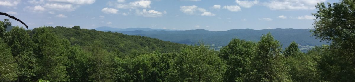
On Wednesday we had a slightly shorter hike to the Wayah Bald shelter. This was our first day of multiple gorgeous views along the trail. Our first peak was the top of Siler Bald at just over 5,000′. Even though we had to walk a few tenths of a mile (without packs) uphill through a meadow to reach the top, the summit afforded us 360° views of the surrounding mountains. I pulled out the PeakFinder app on my phone to put names to the mountains we had crossed or are going to cross. The top of Siler Bald was our first place where we had completely unobstructed views of our surroundings. I was disappointed that we couldn’t see Wayah Bald, which was our next summit, but it turns out, it was tucked in a few peaks away.

At the top of Wayah Bald there is a covered, stone observation tower. I don’t believe it was ever intended to be a fire tower like the one on Albert Mtn., but we did have phenomenal views from the top. Along this part of our trip, we kept crossing back and forth with Wednesday, a lady around my age from Kansas City. Gavin was struggling a bit this day, and she was kind to stop and offer suggestions and encouragement. I hope we run into her farther up the trail. One of the most difficult parts of this day was thinking we were climbing up Wayah for quite a distance before we actually were. At one point, we saw a sign that indicated the distance to the top was “smudge.6.” The sign had been carved on and I read the “smudge” as a zero when in fact, it should have been a one. It was quite disappointing to go a ways down the trail and realize we still had over a mile to go. Thankfully, we powered through to the top. I only wish I had worn my puffy jacket up on the tower so I could have stayed longer.

We arrived at Wayah Bald shelter quite late in the day and there was no room for Gavin to camp inside. We pitched our tents in the best places we could find, but there were way more folks tenting at this shelter than we had encountered before. As a consequence, we had to settle for a couple of spots that weren’t as level as we would have liked. The way my tent was pitched, I had to be very conscious to not roll off my mat. Actually, I had about as good a night’s sleep as I’ve had, even though I remember several times waking up to make sure I still had an appendage hanging over the top of my sleeping pad to hold me in place.

We got a really late start out of the shelter the next morning. By the time we were up and around, the shelter itself had cleared out except for one gentleman who was a two-time thru-hiker. He was nursing a sore knee and said he was going to take a zero at the shelter. We wound up moving our stuff under the shelter and packing there. It was also nice to have use of the shelves/benches to cook and eat our breakfast. Just before we were ready to head out for the day, Travis hiked in. He took an extra day in Franklin because of a family emergency and it only took him a day and a half to catch up with us. It was great to rejoin a good friend. We hiked together for much of the day.

When we reached Burningtown Gap we were once again met with trail magic from the Crawfords and Fresh Ground. The fare was similar to that of two days before, but this time we hung around long enough to enjoy some blueberry fritters. Gavin also enjoyed playing with Rainer and Filia. It was really heartwarming to see Gavin pull out his stuffed dog to entertain Rainer. We were also treated to some great guitar songs by Kami. As I said earlier, it was an unexpected treat to run into “internet legends” along the trail.

The final part of this day was another slog. We had a 3.3-mile trek over the Copper Ridge Bald to the Big Branch Campsite and we thought we’d never get there. Thankfully, we found tent spots that were much more level than the previous day. As a bonus, there was a spring right in our campsite so we didn’t have to go anywhere to hydrate. We ate and went to bed pretty early after a long day of hiking. Unfortunately, we had some pretty loud thunderstorms through the night. On the bright side, we slept late enough that the rain had stopped so we didn’t have to pack our things in a shower. That is the down side to tent camping: it is absolutely no fun trying to get your gear stuffed into your pack inside the tent. Even though the rain had stopped, we still had to pack our tents wet. Thankfully, this was our final day of hiking, so we knew we’d be able to spread the tents out and let them dry when we got into Bryson City.

Our last day of hiking this week was our longest, at 9.6 miles. It was in many ways the most difficult because we lost nearly 3,000 feet in altitude with few uphills to “rest” our legs. Hiking down is often more challenging on the feet and legs because of all the pounding they take and because of the need to “hold back” from going downhill too quickly as to be reckless. Fortunately, we were able to make our destination, the Nantahala Outdoor Center near Bryson City, NC. Gavin and I got there around 5:00, a little after Travis. We ate a light supper, and Beth and Griffin picked us up a short time later for our weekend in the Hummingbird Cabin.

On Saturday afternoon, Beth, Griffin, and I did a little reconnaissance on Fontana Dam, Fontana Village and the resupply options therein. The dam was truly an amazing sight. We were able to look down into the spillways that lead to the turbines. I cannot even describe how large they were. After walking part of the way across the dam (which is on the AT), we drove down to the bottom and took some pictures and videos from that angle. The amount of water coming out of the spillway and gushing into the air was incredible. It amazes me that such a structure could have been completed in 1945.

It was a thrill for Beth and Griff to meet Travis, having heard us talk so much about him. He has been such a positive influence on Gavin and a great hiking partner for me. It was our pleasure to share the cabin with him this weekend. We had a good time just relaxing around the cabin, eating, and going into the local Ingles to resupply. Travis also got to meet Joy, whom he has heard much about from Gavin.

Tomorrow morning we’ll head back to the NOC to start hiking again, and Beth and Griffin will head back home. It has been really great seeing them, and we also appreciate Aunt Sallie for making our cabin arrangements for the weekend. She is truly the queen of the VRBO! Our plan is to get to Fontana Dam by Wednesday and spend one night at the Fontana Lodge. From there, we’ll be hiking into the Great Smoky Mountains National Park for the next 70 miles. We hope to be able to get off for at least one night in the middle at Newfound Gap. From there, we can introduce Travis to the joys of Gatlinburg, TN!

Days 9-16

Before I start detailing our hiking week, let me tell you how much we appreciate you for following us along our journey. We are definitely reading all your comments, but it is proving difficult to reply to all of them in a timely manner. The way things have been going, we have taken a couple of nights off-trail here or there in a hotel or hostel, and that is the best time for us to write replies. Please keep sending your thoughts and encouragements here and on our YouTube channel— we are reading them, and they inspire us to progress up the trail.

Speaking of time in town, our days 9-10 were spent in Hiawassee, Ga. We stayed at the Budget Inn there and had a very relaxing time. As you may see in our videos, the second of those nights was as much for avoiding nearly single-digit temperatures as it was resting and recouperting. While there, we treated ourselves to the AYCE buffet at Daniel’s Steak House, which was superb! We gorged ourselves on the Southern fare of Salisbury steak, fried chicken, mashed potatoes and gravy, and lima beans. It was fantastic.

One of the things we were most looking forward to on this trip was meeting people. I have to report that we have made some really wonderful friends. Before our trip into Hiawassee last week, we had been bumping into a guy about my age from Winnepeg named Travis. With the thought of saving money in mind, we decided to double-up on the hotel room last week. We have continued to hike “together” this week, and are once again next-door neighbors. We both agree that we’ve been placed in each other’s paths for a reason. He and I are alike in many ways, not the least of which is that we are not early risers. He is a patient soul and has been quite an encourager for Gavin as well. I believe that he is one friend from the trail that I will hope to visit in the years to come.

I also mentioned Rick, from PA, in one my videos. We met Rick at Neel Gap and spent a couple of days staying and hiking with him. He actually got off-trail an extra day to visit some family friends in the early part of the week, but he caught back up with us on Day 14 just before we arrived at the Long Branch Shelter. He, too, has been quite a friend to Gavin, and we’ve been blessed to have him along on this journey. Though he stayed here last night, he hit the trail again this morning, but I’m sure we’ll meet up with him again in the next week or so.

When we left Hiawassee on Wednesday, we hiked nine miles to Bly Gap campsite. This was a really cool place to stay. We had a ridgeline wrapping up and around us, and there was a piped spring right in the campsite. I cannot overstate how wonderful it is to have a water source right in the campsite rather than 01-0.2 mile away. Travis and Gavin started a fire and we were joined by Father Time and Gator. We were also later joined by a young lady (I can’t remember her name) who started four days after us. She just finished at UNC and is hoping to complete the trail by the end of July so she can get to med-school orientation on August 1. We had a good time getting to know one another.

Day 12 was onward 7.7-miles to Standing Indian Shelter. We had a really pretty day for hiking this day and saw several views. One thing that was particularly neat that day was a bird that perched on a log long enough to be photographed. So far, wildlife has been scarce, but I did hear an owl one night, which was really cool.

When you seen the Day 13 video, please forgive me for its shortness in length. It rained on us most of the day so I didn’t take much video and there were no views to photograph. We did summit Standing Indian Mtn. which was no small feat at 5,435’. Thankfully, much of the rest of the way was downhill to Carter Gap Shelter. Our temperature was in the low-30’s starting out, but thankfully our gear kept us warm and mostly dry. When we got to the shelter, there was room enough for Gavin to squeeze in, but it got crowded pretty quickly as other hikers arrived. I was able to get a small break in the rain to pitch my tent, and I slept mostly in the dry. The water source for this shelter was a muddy slog a few tenths of a mile downhill, but thanks to the suggestion of another hiker, we set our pots down outside the shelter to catch rainwater dripping off the roof. We accumulated more than enough water that way to do us for the night and the morning.

Our final long day of hiking this week was Saturday, a trek of 8.7 miles to Long Branch Shelter. This was hands-down the nicest, newest shelter we have stayed at. It was bi-level and could probably sleep 16-20 folks, but we only had around ten or so. We all had room to spread out, and we slept well, even though it rained quite a bit on the tin roof overnight. We also reconnected with Kevin and MJ, now Sunkist, whom we met early on along the trail.

Sunday morning we had a short hike to Rock Gap, where we caught a shuttle with Travis to Franklin, NC, where we’ve spent the past two nights. In addition to resupplying our food, it is really nice to spend a day or so resting and letting our muscles heal. There is great comfort in being stuck in a hotel room with only a few items other than eating on the to-do list.

One of the important to-do items for today was to get Gavin some new shoes. Though he started with a new pair of Altra Lone Peak 4’s, we quickly found out that there was not nearly enough “shoe” in them to protect him from all the rocks and roots we have been traversing. As a consequence, his calf muscles had to work overtime to absorb all the shock from his hiking which has lead to him having foot pain. That discomfort, in turn, has caused his hiking pace to slow substantially, especially late in the day. We spent about two hours with Rob from Outdoor 76, an AT Shoe Legend, who helped Gavin get a different pair of shoes that will hopefully see him many comfortable miles up the trail. We are both appreciative of the time Rob took carefully measuring Gavin’s feet, asking lots of questions, while going through several “trial” pairs of shoes before Gavin could settle on just the right ones. Please be prayerful that these are indeed the right shoes for Gavin.

My pains have been mostly in my knees, but not while hiking. I am an active sleeper, starting on one side, then to the other, and then on my back. When I’m on my sides, I keep my legs bent, but when I get on my back I straighten them out. That is when I get a searing pain down the outside of my left (and sometimes right) knee. I think it is the IT band, but whatever it is, I wish it would stop. I think it is because I am restricted in how much I can move my legs around in my mummy sleeping bag. Last night in bed, I experimented with different ways I might sleep in such a compact space with the hope of alleviating the problem. I also wonder if letting just a little air out of my sleeping pad might be helpful. I will report in next week with my progress. In the meantime, I’ll keep doing Vitamin-I (ibuprofen) at night with the hope of getting a more restful sleep.

The highlight of the week was hitting the 100-mile mark atop Albert Mtn. on Saturday. At 5,250’, the climb up Albert Mtn. was a rock-scramble that was near vertical at times. I had a slightly easier time of it than Gavin because of my longer legs, but it was a tough but fun climb for both of us. Unfortunately, the weather was uncooperative and we had no views for our efforts. Gavin climbed the tower, but he only went higher into the clouds, still seeing nothing. At least we were able to use our little tripod to take a picture together at the top.

In the coming week, we’ll wind up at the Nantahala Outdoor Center near Bryson City, NC. Beth and I have been there before on a rafting trip, but I don’t think the boys were with us yet. Another highlight will be the Wayah Bald tower at mile 119.5. There is a stone tower there, and according to the weather I’ve seen, we should get some views. I’m really looking forward to that.

As always, thanks for joining us on this journey. Please leave us words of encouragement in the space below. Even though we don’t reply daily, we’re reading your comments, and they are very meaningful to us. If you have time, please check out our YouTube channel which is linked in the menu above. I’ve uploaded several videos while in town the past two days, and they will come out every day or two. God Bless, and remember to keep taking the Next Step.

Days 5-8


On Day 4, we wound up at Mountain Crossings at Neel Gap. They have a hostel and an outfitter, and word is, 25% of people who start the trail at Springer Mtn. wind up going off-trail there. Out front, there is a huge tree with the boots of folks who gave up the ghost early. We stayed in the hostel on the night of day 4. There we met Rick from PA and Red from Indiana and we agreed to “slack-pack” the next day. For us, that meant getting a shuttle from Mountain Crossings up the trail about 8 miles to Hogpen Gap. We carried only water, rain gear, and a few snacks, so the hiking was much easier. We were able to do the whole eight miles in about four hours. That night the four of us shared a cabin at Gooch Mtn. Cabins.

 After a second night indoors, the four of us got a shuttle ride back to Hogpen Gap and we hiked northward again. Our plan was for Red, Gavin, and me to share a cabin at a hostel that was down a trail off the AT. I got a text from Red that he had missed the turn-off, so he went on down to Unicoi Gap and got a shuttle into the cabin. Gavin and I saw the side trail, but it was 1.4 miles downhill, which meant we’d be doing the same trip uphill the next morning. Since Blue Mountain Shelter was only 1.5 miles up the trail, we opted to head on up the trail. I hope we didn’t put Red out any, but I told him we’d make it up to him up the trail somewhere. This turned out to be an 11.9-mile day, our longest and most difficult yet.

From Blue Mountain Shelter we had a 7.6-mile day to Tray Mtn. Shelter. The day started off with a 200’ climb, followed by a 1,000’ descent to Unicoi Gap where we were met with Trail Magic from BSA Troop 134 from Decatur. We had hot dogs and sodas and headed back up 1,000’ to the summit of Rocky Mtn. That was followed by a nearly 1,000’ descent, which was followed by about 1,500’ uphill to the top of Tray Mtn. The shelter was down the back side of the mountain a short distance. Though the mileage of the day was on par with what we’d been doing, this was definitely our most arduous day of hiking. We slept well, and slept in a little bit, and were the last ones to leave the campsite.

On Sunday we hiked from to Deep Gap Shelter, a distance of 7.9 miles. Gavin really put on the afterburners and left me in the dust. We met up with Jukebox and Timber and hiked much of the day with them. They are definitely much younger than me, but Gavin was able to keep pace with them. Thankfully, they stopped and waited on me periodically. With about 1.5 miles left, we were climbing Kelly Knob and it started to rain. I got my pack cover on, and pulled on my rain jacket, but didn’t take the time to mess with my rain pants. This was a huge mistake! I was hiking in shorts, and in a short time, they were soaked. Thankfully, it wasn’t too cold. Yet. We made our 8 miles in about four hours, which was a new speed record for us, though I still trudge slowly uphill. Gavin and the younger hikers beat me to the shelter by 20-30 minutes. On the way up, I met up with Rick again and we finished the day’s trip together.

When we got to the shelter, there were folks all around trying to get in, get settled, get dry, and get warm. I went down to the privy and switched into my dry wool base layer and covered back up with rain gear and my down puffy jacket. We wandered around the awning for a while watching it rain and waiting for an opportunity to go pitch a tent. Finally, it let up enough for me to do that, but it wasn’t a completely dry pitch. Oh well, live and learn. Gavin stayed in the shelter and made bunches of friends. He brought some waterproof playing cards with him, and he has had much fun playing Egyptian Rat Slap with folks. All the other hikers have really accepted him as one of their own because he has hiked the same miles that they have. They are all really impressed with his tenacity and grit, and the fact that they’re in the company of a not quite 14-year-old thru hiker that is doing as well as they are.

This morning it was about 25° when we left the shelter. It was a real joy putting on boots that had frozen solid overnight. I slept with my water filter so that it wouldn’t freeze and become worthless. We had a short 3.6 mile trip today to Dick’s Ck. Gap where we were picked up by a shuttle driver for the Budget Inn in Hiawassee, GA. We’re staying here for the next two nights because the temperatures are supposed to drop into the low teens. I haven’t looked much farther out, but I expect we’ll have some snow in the coming week. Yay. We are sharing a room the next two nights with a hiker from Winnepeg named Travis.

We had supper tonight at an all-you-can-eat buffet called Daniels Steak House. It was really good- salad bar, fried chicken (and chicken livers), and Salisbury steak, mashed potatoes, and Lima beans! Yummm. Unfortunately, Gavin, who usually picks at his food and isn’t accustomed to eating large meals, ate too much, too fast, and wound up with a stomachache. There were 8-10 other hikers at our table and while Gavin was in the restroom nursing his stomach, they were all amazed at how well he is doing on the hike. They couldn’t stop going on about how well he is hiking, fitting in, and making friends. They are all in awe that he is able to make this trip as a 13-year-old. It made me really proud to be his dad!

I’m going to close by revisiting a tired subject, that of trail names. If you’ve kept up with our posts, you know I’ve been toying with two trail names, Next Step and Aftermath. Funny story: I met a girl on the trail the other day and told her I was waffling between two names, but she misunderstood. She thought I said my trail name is Waffle. Needless to say, it is now. The good thing is, though, that when I explain my name, I can tell the stories of both the trail names I set out with. Gavin was first called Hawk by So Far, So Good, but after we met another Hawk who is planning to yo-yo the trail (Springer to Katahdin, and back), he picked up Hawkeye because of his ability see things that others miss.

I think the thing I’ve enjoyed most so far about the trail is meeting complete strangers and becoming instant friends. We’re all out in the woods walking the same miles, through the same rain, uphills, and downhills, so we have a shared experience. Hanging around the shelter the past two or three nights has given us a chance to make new friends, and we’ll be hiking around each other for the near future until the younger group get their trail legs more quickly than me and start hiking longer days. By that time, though, others will catch up to us, so there will never be a shortage of folks to meet and socialize with. At some point, we’ll fall into a group that has a similar pace and we’ll form a trail family. That will be really cool.

Thanks for following our posts. I’m doing the best I can to get some videos out, but the WiFi in our hotel isn’t strong enough for me to post. I’ll keep trying. Blogging and blogging on the trail has turned out to be harder than I expected because by the time we reach camp, all we want to do is eat and go to bed. I am also not flexible enough to sit cross-legged and type. I really need a chair and flat surface to write, and so far, the picnic tables at the shelters have been too wet to do that on. I’ll try to do better.

Again, thanks for following our journey. I am trying to respond personally to comments, but the same eat/sleep routine gets in the way of that as well. Please do keep sending them, though. It is very encouraging to hear from friends and strangers who wish us well. Prayers are appreciated as well, especially for the uphills that I’m struggling with so. I guess I need to just keep taking the Next Step.

Days 1-4

Greetings, and thanks for checking in on us. We’re four days into hiking and have covered 30 miles so far. We’re inside tonight at Mountain Crossings hostel  at Neel Gap. We’ve done about 8 miles each day so far. Our first night was at Hawk Mtn. Shelter— Gavin slept in the shelter, but I pitched my tent. Both of us slept comfortably. We were greeted at Hawk Mtn. by Santa from Atlanta, whom I have seen in several videos. It was cool to meet a trail “legend,” or at least someone with quite a bit of trail experience. Our second day was to Gooch Mountain. I was planning to tent again, but there weren’t enough flat space to set up so I wound up inside. Santa was there again and has really taken Gavin under his wing. Day 3 was another 8ish miles to Lance Ck. Reforestation area. Ho, ho, ho! Santa was there again. We got a bit of rain last night, but thankfully it finished doing what it was doing before we got going. Today was our hardest day. We climbed Blood Mountain, which was the toughest climb yet, but the views from the top were phenomenal. We met a guy who was trail running who told us a little about the area. On a better weather day, we would have been able to see the Atlanta skyline from the peak. The trip down to where we are now was incredible. To this point, all of our downhills have been gradual and earthen. Today, it was nothing but rocks on top of rocks, but we made it here.

Gavin has been dealing with foot pain for the past day or so, but last night we were fortunate to meet a young woman from Finland who actually had a spare pair of insoles. They seemed to make all the difference for Gavin today. I dealt with a bit of knee pain on the last of the uphill and definitely on the downhill, but it seems to have abated.

To go back to the beginning, we started “hiking” on Saturday. We did the steps up to the top of Amicalola falls. 605 steps! Thankfully, there were landings along the way to stop and put my lungs back where they belonged. Also thankfully, we were with family, and the view was phenomenal.

I would also be remiss if I didn’t tell you about Alaska and his hiking buddy. We met them Sunday at the summit of Springer Mountain, the southern terminus of the trail. Alaska was toting a single-shot pellet rifle for hunting birds and other small game. His buddy was carrying a 14” skillet dangling from paracord on the outside of his pack. They were definitely packing heavy. They were with us the first couple of days, but “Skillit” hitched off the trail yesterday from Woody Gap with the intention of doing work-for-stay at a hostel until he could lighten his load. I don’t know of Alaska’s fate. Thankfully, Gavin and I are much more prepared, but we still have heavier packs than we need.

Edit, 3/4/19: though “Frying Pan” is off trail, Alaska has dropped the pellet gun and an extra pack and is still moving up the trail. We have crossed paths several times and stayed with him last night at Deep Gap Shelter. He is also here with us at the Budget Inn in Hiawassee tonight and probably tomorrow. My turn to eat crow and to learn not to trust first impressions.

As I mentioned above, we arrived at Mountain Crossings, which is a hostel and outfitter right on the trail. They will do a free pack shakedown to give you suggestions of things that you should send home to save weight, and they’ll also suggest items that you may need that you don’t already have (and I’ve heard they’re more than willing to sell it to you.) We’ll have them look through our packs tomorrow. I’m sure they’ll suggest that I ditch my iPad and keyboard (about two pounds worth, together), but I’m still holding out the hope that they’ll be worth it when I feel like writing/editing at the end of the day. Right now, I have been in bed between 7:00-8:00 each night and it is still hard to get up and get going. I’ll be interested to see if they can save us any other weight. I expect our cook kits are too heavy to make it all the way to Maine.

I notice that I am supremely rambling here, but in my defense, I am exhausted. I  am going to go ahead and end here. I am hopeful that as we get into better shape, and on days when we are hiking less distance (or at least finish earlier in the day), I will be able to blog more often, and more thoughtfully. I am also hoping that in the next day or so I can put up some videos on YouTube. What I hope I can do is do one video each day and schedule them to come out one day after the others. So far, we have footage for the first four days, but it’ll take me a little while to put them all together.

Again, thanks for following our journey. We’re having a great time, sore muscles not withstanding. We’re supposed to get rain tomorrow, so pray for us. And always remember to keep taking the “Next Step.”

**Note from Beth: Rob wrote this last night with the intention of my editing and posting this morning, but due to a slight miscommunication, I am just now posting it. They have actually finished hiking for the day (day 5) and are back in town. They “slack-packed” today, which I’m sure he’ll tell you all about in his next update. Anyway, sorry for the delay, and thanks for reading!

Q & A Post

“What are you guys going to eat out on the trail? Berries and ramps?”

It is a fairly common question and the answer is, “Yes.” At least the berries part. Blueberries are rampant (sorry) along the trail once they come into season. Actually, ramps are too, but I’m not so sure about those. Never had ‘em.

In truth, for most of the trip we will be able to get into town every 3-4 days. When there, we’ll shower (yeah!), do laundry, and resupply our food. We’ll also have the option of sleeping indoors in one of the many hostels and hotels in towns along the trail. Even though there are few grocery stores adjacent to the trail, hostels usually provide shuttle service into town for meals and resupply.

Gavin and I did our initial food trip today. I hope we got everything we need. Actually, I’m sure we did, and then some. So what do we eat? Here is our startup menu:

Breakfast:

  • Oatmeal
  • Carnation Instant Breakfast
  • Coffee/Hot Chocolate
  • Cliff Bars
  • Powdered Milk

Lunch:

  • Tortillas with peanut butter & raisins or pepperoni & cheese
  • More protein bars

Snack:

  • Peanut M&Ms
  • Snickers
  • Dried Fruit
  • Slim Jim’s
  • Cheese
  • Fruit Gummies
  • Nuts

Supper:

  • Knorr Pasta or Rice Sides
  • Ramen noodles
  • Summer Sausage
  • Spam
  • Chicken in a pouch

All the above is typical hiker fare which will be heavily supplemented with cheeseburgers and pizza when we get into town.

When on the trail, we’ll be burning 3,000-5,000 calories/day. That averages out to about two pounds of food each day. What I’ve learned about backpacking food is, the more calories, fat, and protein, the better. This seems incredibly wrong to me, but I’ve heard that even though a hiker’s diet is largely junk food (think honey buns for breakfast) for six months, all the extra exercise day in and day out makes it all okay. On a hiker podcast I was listening to today, the 50ish host said his cholesterol levels just off the trail were the best they’ve ever been.

Even though we’ll be eating tons of food that is high in calories and as light in weight as possible, I still expect we’ll lose a bunch of weight. It is not uncommon for a hiker of my stature to lose 40+ pounds along the journey, even while eating and snacking all day long. About a week into our trip, we will develop “hiker hunger,” which is akin to the “see food diet.” For all the demands being placed on our bodies, we will develop an insatiable appetite and will somehow still lose weight. I’m looking forward to that part. I just hope I can turn it off when we get off-trail.

“Are you going to sleep in a tent for the whole six months?”

Yes and no. As I mentioned above, we’ll be able to sleep indoors at least once a week if we want to. Our options in the woods are either our tents or shelters, which are 3-sided structures that are located every 8-15 miles along the trail. They will be a welcome site (see what I did there?) when it is raining or snowing, but my feeling right now is that I’d rather stay in my tent as often as possible. Shelters tend to be crowded, especially in inclimate weather. I’d rather not have to climb over and around folks if I need to get up in the night. They also tend to be a hotbed for norovirus.

“How far are you going to hike each day?”

We are intentionally planning to start slowly to mitigate the chance of early injury and to give our bodies time to adjust. Our stop/start locations will be largely dictated by shelter and campsite locations which are spaced fairly closely together early on along the trail. In the first two weeks, most of our planned days are less than 8 miles, but there are a couple that are 11.5ish. Since we usually hike at a pace of around 2 mph, this will mean 4-6 hours hiking each day. This will give us plenty of chance to acclimate ourselves to the trail. We will also be able to stop to rest and enjoy the views without feeling the need to push onward. Most important, we will arrive in camp with plenty of time to set up in the daylight.

Once we get farther up into NC/TN and definitely VA, we’ll develop our “trail legs,” meaning we will be in top physical shape and can do longer days. I expect that through Virginia, we’ll be able to put up 15-20 mile days with regularity. That will keep up until we get into New Hampshire where we will confront the White Mountains. Because of this section’s difficulty, most folk’s mileage is cut in half there. There is even one area, Mahoosuc Notch, which is called, “the most difficult mile on the AT.” Here, we will be climbing over, under, and around house-sized boulders. It takes most folks 1-2 hours to complete this single mile of the trail.

“How will you keep in touch with folks back home?”

Though there will be periods of interruption, we should have cellular service most days while we are on the trail. With luck, Gavin and I will be able to call home and check in, or at least send messages at the end of the day. We are also bringing along a SPOT Personal Locator Beacon which was loaned to us by a friend. It is a satellite-based GPS unit that will ping our location every 30 minutes. Beth will be able to “see” us on a map, and when we don’t have cell service I can have it send a precomposed message such as, “Made it to camp and are doing okay.” It also has an SOS button on it that will summon wilderness rescue personnel should we find ourselves in a dire situation. Hopefully we won’t accidentally hit that one! For that matter, I hope we don’t hit it on purpose either. With luck, we’ll have enough service to update the blog frequently, if not daily.

“What about bears? Are you taking a gun/bear spray?”

No. There is really no need for a gun for protection on the Appalachian Trail. If the bears have read the same books that I have, they know that they’re way more scared of me than I will be of them, though I’m not really sure that’ll be the case if I encounter one on-trail (mental note: pack extra underwear). The only real danger from bears is getting between a mama bear and her cubs. Bears only come around humans to get their food. For that reason, we will either be hanging our food from a tree limb or putting it in bear-proof containers provided at many shelters. Unfortunately, some people are careless with their bear-hangs, or they just don’t bother. When bears begin to associate humans with food, it usually ends badly for the bear. Last summer there was such a bear in the Grayson Highlands section of the trail, just across the VA line. Because of the bear’s frequent assaults on food bags, a 20-mile section of the trail was closed for camping in that area. Unfortunately, bears that become a nuisance are generally euthanized. Thus the saying, “A fed bear is a dead bear.”

Congratulations! You’ve made it to the bottom of another lengthy diatribe where I try to use as many big words as possible! Gavin and I really appreciate you for following us along the trail, and we hope you’ll send us comments with words of encouragement as we hike northward. If you would like to be notified by email when we post, just put your address in the subscribe box in the right margin of the page. Also, please check out our YouTube channel; subscribe if you like. It is linked at the top of this page.