AT Days 45-55

I probably mentioned in my last post that the Laurel Hostel wasn’t the nicest place to stay, but we were warm, dry, and indoors, so we were good. This post begins where the trail crosses Rector Laurel Rd., only a hundred yards or so from the hostel, so we were back on trail quickly. Most of the day was uphill, but it wasn’t a bad day of hiking.

Since this was a short day of hiking, we arrived at the shelter fairly early in the day. Gavin put his entrepreneurial talents to work and set about making dice from sticks found in the campsite. He was able to sell a couple of them to Kyle (now Rat Tail) and Brooks who had stopped there for lunch. Before supper was over, he had made $9 from his efforts. We really expected to have the place mostly to ourselves that evening, but as the afternoon wore on, more and more people stopped by. The shelter filled, and there were soon 8-10 tents set up behind the shelter. The only issue with the shelter was that the water was about 0.25 miles down a blue-blazed trail, and I mean down.

Several groups of younger hikers came and went as the afternoon wore on. Around suppertime, two hikers, Angel and Bullfrog, came in. It was quite evident that Angel had had a tough day of hiking. After she “let go” for a few moments, Gavin said, “Do you need a hug?” She accepted and detailed how her trail family had misrepresented itself when discussing daily mileage, and that she wasn’t up to doing 16-20 mile days yet. We told her that if she wanted to move a little slower for a while that she should join us, because we were regularly doing 10-12 mile days with a few 13s and 14s thrown in. And thus, a new trail family was born. We are a multi-generational group with Gavin at 13, Angel, 23, Bullfrog, 38, me, 52, and another gentleman who hiked in later that night, Snow Cream, at 65. We quickly gelled as a group, and we’ve been hiking together ever since.

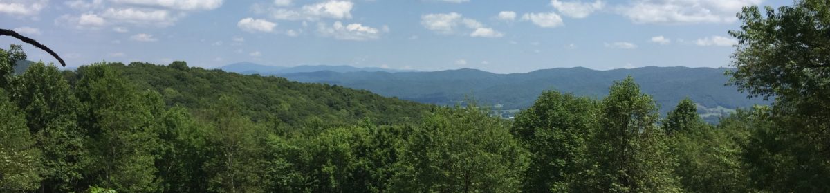
We got a pretty early start on Wednesday. Gavin was tremendously excited about hiking with a new trail family. Most of our hike was uphill, including one particularly steep section to the top of Big Bald, but it was well worth it. The views from the top were absolutely incredible! I was particularly impressed by the pace Gavin kept hiking today. Bullfrog and Angel were out front setting the pace and Gavin stayed right in step. It was difficult for me to keep up on the uphills, but I was proud that I was able to. Our hike today was 10.1 miles ending at Bald Mtn. Shelter.

Thursday was another 10+ mile day to No Business Knob Shelter. I was thankful that Angel and Bullfrog helped get Gavin rousted. Our view of the day was at High Rocks. The top is off the AT about 100 yards up so we dropped our packs before climbing. It was incredible how light I felt going up with just my trekking poles. The views from the top were awesome. No Business Knob Shelter lived up to its name: there was no water nearby, no privy, and no bear cables. There were quite a few people there that night so I decided to tent. We got a little bit of rain overnight, but it wasn’t enough to worry about. I stayed plenty dry and slept well.

On Friday, we had an easy day almost all downhill into the town of Erwin. The plan starting the day was for Beth and Griffin to pick us up at Uncle Johnny’s Hostel and then pick Travis (remember him?) up from a road crossing a little farther up the trail. We got to Uncle Johnny’s around 11:30 so it was going to be a long wait. We ate our trail lunches out of our bags supplemented by some cold drinks from the soda machine and before long decided to see if we could get a shuttle on into Johnson City where we had a house rented for the weekend. It was pricy, but Gavin and I left Angel, Bullfrog, and Snow Cream at the hostel for the night and headed out to Hughes Gap to pick up Travis. We got to our house about an hour before Beth and Griffin.

This was my first experience with a Air B&B. The key was under the mat as it should have been so we unlocked and went on in. We explored the sleeping situation so that the adults could have their own rooms. It was really odd to be in a house that had someone else’s clothes and other belongings in it, and for a while, I wondered if we had the wrong place. We’ve previously stayed only in VRBOs which are generally 100% rental homes. I have to say, it was a bit freaky at first.

Beth and Griff got there around 6:30. The five of us headed out to find food: Outback- steak and ribs combo for me. The trip over was quite an adventure because the GPS route wasn’t quite to the front door. Consequently, we had to go around the block once to make a second pass at the restaurant. We were successful and supper was wonderful!

Saturday morning Beth and I headed back to Erwin to pick up the rest of our crowd. I know she was a bit stressed to have three additional strangers settling in with us for the night, but once she met them, they were all instant friends. We spent the day lounging around and eventually headed to WalMart for resupply. For supper we walked to an authentic Italian pizza place across the street from ETSU. It was wonderful! Food is one of the things I miss most when I’m on the trail. Gavin and I have long since tired of instant potatoes, and to be truthful, we’re about to be full-up of rice/pasta sides as well. We’re going to have to start thinking about some new dinner options pretty soon. The trouble is finding something lightweight with plenty of calories and protein. I think we need to start adding chicken to our evening meals, but smaller packets of it are hard to find and the larger packs are heavy.

One of the additional perks of having Beth and Griffin come out to meet us on the trail is they bring some food from home and they can take extra items back with them. I swapped my sleeping bag back to the one I started with for a 1-pound weight savings. I also sent home my 14-oz sleeping bag liner and Gavin’s pots and stove since we have been sharing mine for a couple of weeks. I am still incredibly jealous of those folks on the trail that are hiking with sub-20 pound packs. I have racked my brain over and over trying to figure out what I can do to lighten my 35-lb pack, but aside from the things mentioned above, I’m coming up empty. Maybe when spring hits I can send a few more things home, but I don’t know what they’d be other than my wool long johns. For one other weight-saving measure, I swapped my iPad with a new iPad Mini which is nearly a pound lighter. I just haven’t convinced myself that I could blog on a screen the size of my phone.

On Sunday, Beth and I headed out with Travis back to Hughes Gap. It was really good to reconnect with an old friend whom we haven’t seen since our second day at Standing Bear Hostel. Unfortunately, we dropped him in horrid weather at the base of Roan Mountain. He texted me later that he had rain, sleet, snow, and 60 mph winds going up and over. I am really sorry he had such a miserable day of hiking, but I’m glad that he was willing to come off the trail to visit with us for the weekend.

When we got back to the house we began trying to figure out how we were going to get our family of four plus three additional hikers, a dog with a huge crate, five packs, and all of Beth’s and Griffin’s luggage to fit into the van. As luck would have it, the owner of the house drove up just as we were beginning to pack the van. She offered to take a few packs and bodies back to Erwin. Gav and Bullfrog rode with her and they had a lively chat about slingshots and paintballs. I am very afraid!

Back at Uncle Johnny’s, we said our goodbyes and headed back up the trail. We had only 4.3 miles to go to Curly Maple Gap Shelter. We left around 3:00 and were rained on for the first hour. Thankfully, the rain abated and we hiked the last hour in the dry. There was one other couple at the shelter, so it was nowhere near full. We all spread out inside to spend the night. The forecast was for much more rain, and about 8:00 it started. We all slept dry and fortunately, the rain had stopped before we set out hiking the next morning.

We set out fairly early in the day for our longest day of the week. We had a 12.8 mile trek to Cherry Gap Shelter. I was really excited about hiking this section of trail because it is a section I’ve hiked twice before when I was a teen. The highlights of the day were crossing Beauty Spot, a great bald with incredible views, and passing through the spruce forest atop Unaka Mtn. We quickly learned that temperatures on both these peaks were significantly lower the night before than what we had in the shelter, so they were covered in wind blown ice. The trees were absolutely gorgeous, shimmering in the sunshine. Between Beauty Spot and Unaka, the winds increased and the temperature decreased. Angel, a Florida native, absolutely did not enjoy that part of the hike. At one point, we all stopped, huddled around her for warmth, and shared clothing to block the wind. She is 5’1” and was wearing my XL rain pants to block the wind and Bullfrog’s down jacket for extra warmth. She looked like Randy from A Christmas Story in the scene when he was all dressed up for the bitter cold and couldn’t put his arms down.

Even though I had hiked this section before, I really didn’t remember the absolute beauty of Unaka. It was reminiscent of the spruce, moss, and fir forest that we passed on the way to Clingman’s Dome. I still marvel at the incredible beauty of the sights we’re seeing on the trail.

We stayed at Cherry Gap Shelter on Monday night. It was absolutely the most crowded shelter area I’ve seen. I believe the “bubble” of hikers is beginning to catch up with us. The shelter was full and there were tents everywhere. I pitched in what I thought was a flat spot right beside the shelter, but when I laid down in my tent, I found out that there was a definite slope to the ground underneath. I fought to stay on my sleeping pad all night. In retrospect, it was probably good that there wasn’t room for me in the shelter. It had a low overhang and I hit my head five times. I’d probably have had a concussion if I had stayed inside overnight.

On Tuesday morning we all woke with the crowd of people packing up and hiking out. Snow Cream is an extremely early riser and was already packed and eating breakfast when I came out of my tent. His plan was to hike ahead of us to Greasy Creek Friendly, a hostel several miles up the trail, to get a few food resupply items. We thought he would catch back up with us at the Clyde Smith Shelter later that day, but when we turned in, he still hadn’t shown up. We didn’t have service to text him, so we were a bit worried about his whereabouts.

Our first three miles of the day landed us at Iron Mountain Gap. We waited for quite a while on Gavin. Usually he is with us or only a few minutes behind. This time, though, it was 20-30 minutes. He came out of the woods very slowly and was obviously not himself. I sent Bullfrog and Angel on up the trail and told them that we’d catch up with them at the shelter, if not before. Gav was a bit weak and had an upset stomach which we attributed to his high carb, low protein diet, along with the Mio caffeinated drink mix. I got him moving forward slowly, and eventually he felt somewhat better. He was almost able to get back to his normal hiking pace an hour or so later on.

We caught back up to Angel and Bullfrog a bit later and hiked on. At one point, at the top of a particularly arduous climb, we stopped to wait on Gavin again. Once again, we waited for more than a few minutes. Again, I sent my companions on and continued to wait. After a great while, I decided to drop my pack and hike back down the trail looking for Gavin. I passed a hiker coming my way who saw his pack but not him. When I finally reached his pack and called out for him, I learned that he had gone off trail to do what a bear does in the woods. I guess his stomach was truly upset because it was a much longer trip than usual. Duty done, he packed back up and we headed back up the hill to where I left my pack. Bullfrog had gone only a few feet up the trail and waited on us so we hiked together for the next while. Gavin was obviously feeling much better. When we passed the side trail to Greasy Creek, Gavin stopped to get water and told us to go on ahead. It was two miles to the shelter which Bullfrog and I were able to do in about 40 minutes. To our surprise, Gavin came in only a few minutes later. Apparently he had fully recovered.

What was to happen later this night was beyond prediction. I had stepped out of the shelter, which was a bit off the trail, to call home. I was talking to Beth and I noticed someone walking in with a dog. As they got closer, I told Beth that the dog has the same pack that Joy has. Closer still, I remarked about the bungee leash the dog was tethered to, also like ours. A moment later I said, “That looks like Jill,” a good friend from home. Just then Beth started laughing and I realized that it was Jill and Joy. They had parked at Hughes Gap and hiked in for an overnight visit. In addition to the dog, she also brought my new shoes and some food and drinks for the rest of us. It was the best trail magic yet!

Overnight we learned that Joy is not a good shelter dog. I don’t think any of us got much sleep that night for Joy wandering back and forth through the shelter. Apparently the mice kept her awake, so she kept us up too. The next morning we got up to hike out with Jill and Joy. We made it to Hughes Gap in no time and stopped to have our lunch. We once again gave our thanks and bade Jill goodbye and started our climb up Roan Mtn.

We had more than 2,000 feet of elevation gain in just under five miles to reach the top of Roan. Surprisingly, the trail was incredibly well manicured and graded, so it was one of the easiest climbs we’ve experienced. The top of Roan was incredible and I was surprised that I’ve never been there before considering how close I live. We stopped at Ash Gap to resupply our water before making the final climb to Roan High Knob Shelter.

Roan High Knob is the highest shelter on the Appalachian Trail at 6,186’. It is a fully-enclosed cabin with room for 15 or more people. We were nowhere near capacity, but we did catch back up with Wednesday and Barefoot there. To our surprise, Snow Cream caught back up with us at the shelter that night. It was good to see him and have him in our group again. We each slept well that night and woke the next morning eagerly awaiting the many balds that were ahead of us.

Thursday was a great day for hiking. We had excellent cloudless weather as we ascended first Round Bald and then Jane Bald. We had incredible views from both. One thing that again impressed me was that I had never been there before. I promise that I’ll be back— it is less than two hours drive from home. Our hike Thursday was short, only 7.1 miles, and we ended at the Overmountain Shelter.

The Overmountain Shelter is the one place I wanted to be sure to stop. It is actually an old barn that is 0.1 off the trail. When we got there, we had our choice of sleeping locations in the upper loft. Wednesday had researched the storm that was coming in later in the evening and guided us to sleeping spots that wouldn’t be sprayed by water blowing in through the boards. Before long, the upstairs was filled to capacity and there were several tents pitched down below in the area where tractors used to pull through. Among the crowd were Hippie, Drop Bear, and Respect whom we had met at Standing Bear Hostel several weeks ago. It was good to see them again. Drop Bear in particular was impressed at how Gavin had matured on the trail in just the few weeks he’s known him. I concur.

The biggest surprise of the evening was meeting Blaze, a 2017 thru hiker who packed in trail magic from the road below. He had candy bars, drinks, and fruit for all who wished to have some. He and another hiker even went back down for another load. Trail magic is always an unexpected and welcome surprise!

For the first time in a while, the weather poured in over top of us during the night. Since mid-afternoon the winds had been gusting mightily, blowing in a storm. When we woke, our forecast was for 1-2” of rain. Thanks be to Wednesday who got on her phone and arranged a shuttle to pick up 12 of us about a mile down the road from the Overmountain Shelter. None of us wanted to hike across the remaining balds in the gusting winds with the possibility of electrical storms. We landed at Mountain Harbour Hostel, but the only sleeping space they had was on the floor of the dining room. I was able to get a call out to their competitor, The Station at 19 E, and they graciously came to pick us up and took us in. We each have a bunk to ourselves, many of our friends are here, and there is beer and live music downstairs. Needless to say, we’re happy to be here.

I apologize that it has taken me so long to update the blog. I’m hopeful that as the days get longer, I’ll be able to write a little bit each night in my tent so that when I get to a place with WiFi I’ll have something to upload. It should also make the posts more interesting because details of each day will be fresh on my mind. The same is true with the YouTube videos. It takes strong WiFi to upload them, and I definitely can’t do that over cell signal on the trail. I’ll have to start putting them together before we get to towns so I can just upload a bunch at one time when we’re in town.

Thanks once again for joining us on our trip. We are grateful to those of you who have commented on the posts or have prayed for us. We make it a point each day to pray for ourselves before setting out on our hike each day. We look forward to sharing our adventures with you in the coming week as we bear down on Virginia. Please subscribe to be notified by email when we post, and remember to just keep taking the Next Step.

Days 37-44

Our last update was from Standing Bear Farm. We had planned to hike out on Sunday, but I fell victim to a bottomless coffee pot and Gavin settled in by a fireplace with a quilt and a cat. Added to the less than optimal weather, we decided to stay a second night. Standing Bear was a great place to meet people and visit, and the hospitality was incredible. It was great to be indoors, especially with really low temperatures predicted. Our cabin was equipped with a gas fireplace which was great, except that there was a fine line between low and hades. Since Gavin and I were in the loft, we benefited most from the heat. Actually, Gavin fell right to sleep, but I lay on the bed in my skivies until after midnight trying to figure out how to fall asleep in the sweltering heat. Eventually, I had to get up and go outside to the privy, and a few minutes after, one of our cabin-mates did as well. I asked when she returned if we could please turn off the heat. I guess I could have just done it, but I didn’t want the other two folks to think I was trying to freeze them out. At any rate, we did turn the heater off and it started to cool down almost immediately. The cabin was built over the creek that runs through the hostel, and I noticed the next morning that there were places where you could see daylight between the floorboards. Around 4:30, I woke up again, this time wrapped up in my quilt trying to decide whether to risk climbing down the ladder and making noise trying to turn the heater back on. Again, fate was on my side because Jazz Hands got up and turned it on just before I was going to trek down. She was able to set the temperature to low instead of hades, and we slept well the rest of the night.

Now to get back to the week in question. On Monday we hiked out of Standing Bear about 11:00. Though we had planned a shorter day of 6.9 miles to Groundhog Creek Shelter, what we didn’t plan on was climbing 3,000 feet to the top of Snowbird Mountain in the first five miles. It was a really hard start to getting started again. We were able to have a nice lunch at the top of the mountain and we were both grateful that the rest of the day’s journey was downhill.

Part of the way up Snowbird, we met up with Wednesday, a hiker friend we’ve crossed paths with several times since our second week on the trail. She and Gavin hiked together most of the way up Snowbird, but she left ahead of us from our lunch break. We caught back up with her just before we arrived at the shelter. There we met two section hikers who had pitched their tent in the shelter. At least they were gracious enough to point out several tent sites nearby. Gavin was a bit disappointed because he prefers to stay in the shelters, but he made the best of the situation. I found a flat spot and set up my tent. A little later on, Wednesday and I were talking, and we decided that if it was us in their position, we’d like to be told that it is a major breech of shelter etiquette to put your tent inside. She broke the news, and they were glad to have learned. They pulled the tent out and set it up nearby and Gavin immediately moved in. Not much later, a couple from Germany, now known as Hansel and Gretel, came to the shelter to claim a spot for the night. I hope we didn’t offend the section hikers, but it is kind of crazy to fill up an entire 6-person shelter with a 2-person tent.

I would like to say we were up and out early the next morning, but that never happens. We had planned our first long day that week so that we could get on in to Hot Springs. It seems that no matter where we start, we wind up walking uphill for the first part of our day. It was no different on Tuesday. We climbed steadily to the peak of Max Patch, the first large bald on our trip. The weather was much the same as it was when we climbed Clingman’s Dome- not quite socked in, but cloudy nonetheless. We also experienced some blowing snow on the trip up, and the summit was windy and cold. We did take the time just off the peak to have lunch and talk with a few day hikers. We thought that the rest of the day would be downhill, but that would only have been the case if we were stopping at Roaring Fork Shelter. We did drop by for a rest, but we continued on to Walnut Mountain Shelter to finish a 13.1-mile day. Beth told me on the phone that night that I now qualify for a half-marathon sticker.

The water source at Walnut Mtn. Shelter was quite a distance away, so we were thankful to have enough left from our hike to make our supper. After a long day, I was glad to retire to the solitude of my tent. It was a good decision, because I learned the next morning that there was a huge snorer in the shelter. While Gavin was waking, I headed down to the water source and was able to harvest just enough to make my coffee. Fortunately, Gavin had enough water left to start our hike for the day and make it to a nearby stream on the trail so we set out. Once again, after a brief descent, we had quite a climb to make that morning. We were blessed that after clearing Bluff Mountain, the rest of our day was over fairly benign terrain past Deer Park Mountain Shelter to downtown Hot Springs. We settled into a hotel room at the Alpine Lodge to end a second 13.1-mile day. It is nice to be off our feet.

We have been quite comfortable in our room, though it was only after I had paid for the lodging that I learned that there is no WiFi here. I was able to edit some videos last night, and the library a few blocks down the street has great service. I’m sure I was able to get two, and maybe three, uploaded to be released over the next few days. We spent a bit of time today exploring the downtown area which, honestly, didn’t take too long. We have eaten well, and we have relaxed in the room. I spent a bit of time this afternoon planning our days for the coming week or so. We are hoping to be able to make it to Erwin, TN by Friday. I am proud to say that we don’t have any 13-mile days coming up in the next week!

On Friday, it was time to head back out on the trail, but we were moving slowly. We got out of the hotel around 10:00 to go back up to the restaurant for breakfast. Again, it was quite a treat. We saw several hikers there, many of whom were just getting into town. After returning to the hotel, we got our bags organized and set off down the street at noon. We took a brief break at the Visitor’s Center to take advantage of the WiFi and order some shoes, and we were on our way.

The trail out of town crosses the French Broad River and then cuts upstream, paralleling the river for a ways. Then it zig-zags up the mountain face, providing better and better views of the town and the river the higher we climbed.

On our way out along the river, we met Elvis, who had decided to start hiking from Hot Springs. He was sitting by his pack snacking and asked if he could join us. We said sure, and watched him “pack up.” It was immediately evident that he was a complete newbie. The first clue was the huge Stanley thermos stuck in his pack. The second clue was that he didn’t securely fasten his hip belt. For those who don’t hike, the hip belt is the most important part of the pack: it should cinch down above your iliac crest (hip bones) and should carry the majority of the weight. The shoulder straps are only there to stabilize the load and keep it from pulling you backward. We helped him make a few adjustments to his pack and we were off.

We hiked a little over eight miles to a campsite that was near a fire tower. I hiked well ahead of Gavin and Elvis, and eventually, Gavin passed him by. We arrived at the campsite before 6:00 and began setting up our tents. We were there with Seth and Brooks and Seth’s dog Zaffer. Though we had seen them at Standing Bear, we hadn’t really met them or talked to them much, but they were good company.

As we were finishing our supper, Elvis staggered into the campsite. He set about pitching his tent and immediately ran into an issue: he had never put his tent up before, so he didn’t know how. Brooks and I tried to help him get his ground sheet attached and left him to finish. Before long, it was apparent that the rain fly he had was nothing more than a 4’ x 6’ square tarp, which was not the correct fly for his tent. Knowing that there was a chance of rain that night, I helped him rig the tarp between two trees and his trekking poles to keep him from drowning if it came a downpour. Thankfully it didn’t rain and he survived the night.

We set out the next morning with our sights on Little Laurel Shelter, 11.3 miles ahead. Seth and Brooks went ahead of us, and Gavin, Elvis, and I left together. As is usual, I hiked on ahead of Gavin. I’m not sure if Gavin was self-conscious of passing Elvis, or if he thought Elvis needed a friend, but the two of them hiked together for a while. Eventually we came to a road crossing where I waited a few minutes on them. The other two guys had crossed the road and were resting and snacking on the other side, so we all pulled up for a few minutes. Seth and Brooks were looking for hostel options and Elvis decided he would check out opportunities for work-for-stay. Apparently he was able to find something, because we all made it to Little Laurel without him that evening.

Our original plan for Sunday was to stop at Jerry Cabin Shelter, a little over 7 miles away. Unfortunately, that would leave us a 10-mile trip on Monday to Laurel Hostel and it was supposed to be raining. After looking at the elevation profile of the trail we (I) decided that we should push on to Flint Mountain Shelter, 14.1 miles ahead, so that we didn’t have to hike so much in the rain Monday.

The trail Sunday wasn’t too tough for most of the day, but we did have some great views. We passed a section hiker fairly early on who advised us to take the “bad weather trail” around Big Firescald Knob. We opted for the white-blazed trail and even though some of the rock scrambles were tough, the views were among the best we’ve seen. Near the summit was Howard’s Rock, a precipice large enough to spread out and eat lunch on, and the view from there was phenomenal. Gavin and I both agreed that unless the weather is a full-on lightening storm, taking the side trail around Firescald Knob would be a huge mistake!

From Firescald to Jerry Cabin was mostly downhill and we crossed a big milestone: 300 miles! We stopped there briefly to rest and then continued on up the trail. We had a small climb to Big Butt Mountain, which also involved some rock scrambling. Once, I had to pass my trekking poles down to Gavin so I could use my hands to climb down one particularly tricky section. Though the views weren’t quite as exquisite as the ones from Firescald, we were again glad we didn’t take the “bad weather trail” around this peak.

With Big Butt Mtn. behind us, the rest of the trip in the afternoon was a gradual downhill until just at the end. Then it turned into a knee-straining downhill. It was one of the most strenuous descents we have had since the 4-mile section just before the NOC. Just after that, we had a slight uphill section of less than a mile to the shelter. After bragging all afternoon how great the trail was and how wonderful the weather had been, about 0.2 miles from the shelter it started drizzling. We made it there quickly and began unpacking our stuff to set up for the night. Seth, Brooks, Zaffer, and the two of us had the shelter to ourselves that night and it was very peaceful. The shelter opened to the east and a sunrise viewing was briefly mentioned, but we all decided quickly that that was highly unlikely.

One highlight of the Flint Mountain Shelter was a bit of trail magic we encountered there. A man and his wife who are trail volunteers with the Carolina Mountain Club came by to check out the trail and see if the privy needed attention. His wife brought with her some individual bags of chips and a box of Thin Mint Girl Scout Cookies. Needless to say, they didn’t last long with hungry hikers nearby.

This morning we got up and out more quickly than usual and hiked the three miles down to Rector Laurel Rd. where the Laurel hostel is. I can really tell that Gavin and I are getting faster, especially on level trail or gradual downhill sections. We covered the distance in just over an hour. We were blessed that the rain that was forecast held off until about an hour after we arrived at the hostel.

The Laurel Hostel is mentioned in AWOL’s guide, but there is little said in Guthook about the place. Upon arrival, I realize that once again, we may not have chosen the optimal place to stay for the night, but the shower was great and our laundry is done. The living quarters are not optimal, but it is no worse than staying in a shelter. Later this afternoon, we are going to get a shuttle into town to resupply (at $15/head). Live and learn, I suppose. I expect this will be a cash only deal, so I’ll have to remember to get some when I buy groceries. Tomorrow morning, we’re back on the trail, heading for Erwin by the weekend.

As always, we appreciate you for taking the time to read about our trip. We never cease to be amazed at the kindness of both our friends, and more surprisingly, the many folks whom we don’t know at all who are following along. We have received generous offers of Trail Magic all along the trail and we are most thankful for it. Again, thanks, and remember to just keep taking the Next Step!

Days 31-36

Tuesday was a complete zero day in Gatlinburg. It was really nice to sleep in, knowing that we didn’t have to be anywhere or do anything other than get food. That turned in to an ordeal, but it was exciting. We left the hotel room around noon and walked through town seeing the sights as we went. I should add that it was a spring break weekend for many folks, so it was incredibly crowded. It was also the week of the Tennessee state FFA convention, so there were blue jackets and black slacks and skirts as far as the eye could see. As we walked through town, Gavin noticed several places he’d like to visit after our shopping trip.

The Ripley’s Aquarium is the hub of the trolley system in Gatlinburg. It was a mile or so from our hotel, but it beat walking 3 miles out to Food City on our own. We waited about 30 minutes, and for 50¢ each, we got a ride to the grocery store. We all decided that grocery shopping would be much easier if they’d put all the hiker food in one place: Knorr pasta sides, pepperoni, Slim Jims, spam, and such. They should just have a hiker aisle. We were hoping to get our shopping done before the trolley had turned around and come back by, but no such luck. We waited at the bus stop for another 30 minutes or so and talked with a couple of families who had chosen to park at the grocery store and trolley in to town. They were interested in our trip and couldn’t believe we had hiked over 200 miles already.

After our shopping trip and trolley ride back into the main part of town, Gavin and I dropped our groceries and went back out to see some sites. He wanted to do an escape room, but we decided on Ripley’s Haunted Adventure instead. It wasn’t too expensive, but it was somewhat of a bust. Lots of lights and sounds, and some fishing line hanging down with “fly sounds” playing, and a few jump scares. It would have been interesting to walk through with the lights on to see the “backstage” views. Just outside of the Haunted Adventure was Hollywood Cars. It was a little more expensive, but even though Gavin and I aren’t car nuts, it was fun to walk through. They had quite a few cars from the Fast and Furious series, but they had plenty of cars from my era as well. We saw one of Andy Griffith’s patrol cars, a General Lee, and the DeLorean from Back to the Future. After getting our tourist fix, Gavin and I headed back to the hotel. Travis and I went out for a great cheeseburger at a restaurant whose name I cannot remember, and we retired back to our room and devices for the evening.

Wednesday morning we were up around 9:00 or so and took our time packing our gear. By 11:00, we were heading across the street to the NOC Outfitter in search of a shuttle back to the trail. Unfortunately, the only shuttle listed in our guidebook wasn’t operating that day so we headed down to the road and stuck out our thumbs. We only had to wait 10-15 minutes or so before the Bunch girls, a mother-daughter team from SC who were vacationing in Gatlinburg, picked us up. The mom is planning to hike a portion of the trail this summer so she was quite interested in hearing tales from the trail. The trail was quite good to us in Gatlinburg!

Upon arrival back at Newfound Gap, we set out to go up the trail. There were tons of folks there, many of whom were also interested in talking to hikers. It was fascinating to see people’s faces when they heard “13-years-old” and “2,200 miles.” We spent at least 30 minutes talking to folks before we set out on the trail to Icewater Springs Shelter. Even along the way we ran into day-hikers who wanted to stop and talk to us about our trip. It turns out that Charlie’s Bunion is an 8-mile round-trip hike from Newfound Gap, so there were tons of folks out for the trip. Even after we got to the shelter, people would stop by, both going out and coming back, to see where hikers “lived” and to talk to us. My favorite folks were a couple of families with several young children who had bunches of questions for us. Realizing that I had packed out entirely too much food for the next few days’ journey, I shared my Little Debbie Oatmeal Cream cookies with the kids. One young boy was incredibly interested in following our hike, so I wrote down our website and YouTube info for him. I hope he subscribes and is inspired by our journey.

Late in the afternoon three older gentlemen from near Atlanta stopped into the shelter for the night. They have been doing an annual weekend hiking trip for over 30 years. It was great to meet them and hear the stories they shared. We also met up with four hikers whom we had stayed with a few nights before the Gatlinburg break. They didn’t have such a great time getting into Gatlinburg. They had arranged a shuttle at Clingman’s Dome, only to find out that the road up was closed. They wound up having to hike about 7 miles down the road and were charged a “waiting” fee by their shuttle driver. For the 7 miles they walked, they could have come straight into Newfound Gap and have had a much easier time getting a shuttle. I was almost ashamed to share with them our many strokes of luck getting into and out of town.

We slept well at Icewater Springs shelter and got up and out early for a big day of hiking. Only a mile in was Charlie’s Bunion, a huge rock outcropping with incredible views. Gavin, the adventurous one, climbed up on the rock to see what he could see. I stayed on terra firma taking pictures for other hikers. After 10-15 minutes, we were off down the trail. We had tons of views on Thursday which I will share on our YouTube channel.

We made our destination of Tri-Corner Knob shelter, which was the most convenient shelter site we have stayed at so far. The water source was only a few feet from the shelter, and the bear cables and privy were less than 100’ away. Here we met back up with Mike and Kathy, whom we met much earlier on our trip. Kathy kept remarking about how much weight I had lost, and how good we were hiking to have made it this far. I was just pleased to have done more than 6-8 miles in a day. I think we are at a point where we are strong enough to be upping our daily mileage. Even though it was a long day, neither of us were too tired and sore. Even my knee didn’t bother me too much on the trip.

In order to get ourselves out of the Smokies, Friday was set to be our longest day of hiking yet- 14.6 miles to Davenport Gap Shelter. One trail feature that was NOT in our guides was the ice on the trail. Though we had encountered some ice previously, it was nothing to compare to today’s hiking. Mostly, the trail had been slushy, but since we were out early on a cold day, the slush had turned to solid ice. We must have hiked for a mile or so hoping to get a foot on a rock or some snow to keep them from shooting out from under us. Thankfully we made the trip without a fall, but I had a couple of close calls. It was ironic because just before we had encountered the ice, I shot a video about my favorite piece of gear: my trekking poles. They have saved my fanny several times from falls. In fact, I’m only up to two falls so far, and both of them have been just after I was fiddling with my camera and didn’t have my poles in full operation after clipping my phone back onto my shoulder strap.

On our hike today we passed Cosby Knob shelter after about 7 miles. I almost lost Gavin there. We ran into Mike and Kathy there, and Gavin really wanted to stay and visit. He was convinced that he couldn’t hike 14.5 miles, but after some cajoling, we were off and on the trail again heading for Davenport Gap Shelter. After a small climb, the last 4 miles of our trip today were downhill. While it was nice to not be fighting gravity to get up the trail, it was actually fighting against my knees on the way down. They wanted to slow me down and keep me from barreling down the hill, while the trail wanted me to be down as quickly as possible. I am glad my knees won the battle, but it was at a cost. I am grateful that I brought a brace with me, and I certainly put it to use this day.

I was so proud of the way Gavin hiked on Friday. I got behind him a few times, and it was interesting to see how he has matured as a hiker. Where he was once stopping and stepping over water bars and rocks, he is now bounding right over and trusting his pace and trekking poles. We have finally gotten to a place where I believe we can make a 2mph pace, even when we have some uphills. Even though he had doubts about doing 14.5, he hiked the last two miles faster than I did.

Davenport Gap Shelter was not very big, and it was also not very crowded. There were only two of us on the bottom “floor” of the shelter, and Gavin may have been alone on the top. This shelter is the only one in the Smokies that still has fencing across the front to keep the bears out. I have heard that all the shelters in the park originally had such fencing, but much of it was removed because people would “lock” themselves inside and feed the bears through the fence, exacerbating the bear/human interaction problem. As yet, we have not seen any bears, but we did see one print in the snow that might have been a bear.

Our Saturday hike was an easy one, 3.8 miles back to “civilization” at Standing Bear Farm. Though we descended over 3,700 feet on Friday from Mt. Guyot to Davenport Gap Shelter, we continued on downhill to Davenport Gap proper where we exited the GSMNP. We enjoyed the park, but with the strict camping regulations, our daily mileage was either very long or very short. I feel like we’re ready to do 10+ miles each day, but doing 12-14 on a regular basis is not in our cards.

Standing Bear Farm is a quite interesting place to be. All of the buildings are made from reclaimed wood and there is an eclectic, artsy feel. When you check in, you get registered and are given a tour of the farm. They have laundry, showers, a privy, and a resupply store. They even have someone who cooks lunch and supper each day. The whole place is on the honor system. When you go into the resupply room, you pick up a piece of paper and keep track of everything you “buy.” The guy selling food also makes his mark on this paper, and when you check out, you tally up and close the tab.

We have met quite a number of really nice folks here. Gavin found a Risk board and was able to get a couple of folks to play with him. They must have been at it for 3-4 hours yesterday, and after that, they played Texas Hold ‘em for another hour. It has been very rewarding to me to see the older folks take Gavin in as one of their own. He has already seen and learned so much on this trip that he wouldn’t have experienced otherwise. I have also been honored by the many comments made to me about Gavin and what a fine young man he is and how great it is of me to have brought him with me on this trip. I have been proud of the job Gavin has done, and I am glad to have him as my hiking partner.

That brings us to today, Sunday. I got up for a few minutes around 8:00, but decided to lay back down. I finally got up for good around 10:o0. In the kitchen area I found a coffee pot and some friendly folks. The weather is colder today, and it started raining overnight. Travis got up and was gone before we awoke. I was faced with the decision of whether to hike or not today. The next shelter out is right at 7 miles uphill and the weather has been forecast to be in the low 20’s tonight. It didn’t take much convincing for us to stay here another day. Gavin spent the morning in the bunk house with a fire, a quilt, and a cat, and it was apparent to me it was going to be difficult to get him to move today. As I said above, once I found a coffee pot, it was game over for me. We heard from Travis that we made the right decision. He said the shelter ahead was not the best, and that he had dealt with both rain and snow on his hike today. I have been holed up in the kitchen all day working on videos and this blog entry and I must say I’m glad to be here. We are looking forward to spending another night in the cabin with Wednesday and Jazz Hands. We’ve been promised that the heater will be on, and that we’ll have a cat to keep any stray mice at bay. We will be hiking tomorrow!

Thanks for checking in with us this week. We hope to be in Hot Springs in three days. We’ll have to hike extra miles in the next two days to catch Travis, but I believe we can do it. Hopefully we will be able to upload some videos from there. We hope you have a good week, and remember to just keep taking the Next Step.

Days 26-30

Our first day out this week was a short one, but don’t think we didn’t have a tough hike. We started on Thursday morning by getting a shuttle from The Lodge at Fontana Village back down to Fontana Dam. Needless to say, when you start at water level, about the only way to go is up. We had a 6-mile, 2,o00 foot climb to our campsite at Birch Spring Gap. The first mile or so was across the dam and up a roadway where the trail broke off and we entered the Great Smokey Mountains National Park. Just a few feet up the trail there is a box where thru-hikers are supposed to drop one part of their permit before entering the park. As we were doing that, we met a ranger who told us the weather would be so-so for the day. He was right. Part of the day was nice, but once we started climbing, we began to experience sleet and freezing rain. It wasn’t enough to be annoying, but it was one of our first experiences in dealing with frozen precipitation. I suppose the greatest disappointment of the day was not taking the 0.1 mile side trail to the fire tower at Shuckstack. Ordinarily, we would have certainly done it, but by the time we got up there, the weather had us pretty much completely socked in so there would have been no views to warrant the side trip.

After an arduous 6-mile uphill trek, we arrived at Birch Spring Gap campsite. I am thankful that Travis noticed it in the guidebook, because our original plan had us going 11+ miles to Mollie’s Ridge Shelter. That would have made for a very long day. It turns out that Gavin and I were a significant majority in the campsite. Travis, of course, is from Canada. The gentleman staying right beside us hailed from Ireland, and across the valley were two guys from Isle of Man. If nothing else, Gavin has had more exposure to folks from other countries than he would have ever experienced in our small hometown.

After pitching our tents, Gavin went to the campfire ring to start a fire. I was really proud of him. He was able to find some poplar bark which he worked into tinder, and we had plenty of twigs that were dry enough to catch. Though the poplar bark was a little damp, once he got some spark into it, he was able to blow it into enough flame to light the kindling. Before long, he had a roaring fire going to keep us warm. That chore complete, we began our cooking process. It isn’t much of a process. Dump a package of Knor Pasta/Rice into a pot, put in a little water, boil it, and wait. At the precise moment when I was sure the pasta had soaked enough to be edible, a sleet storm set in. Within just a few minutes, there was enough sleet to whiten the ground and put out our cozy fire. We quickly finished our supper and retreated to our tents. Thanks be, the storm didn’t last too long. We were able to knock the sleet off our tents and Gavin went around the campsite collecting it to make little snowmen. They really were quite cute. He made sure to take one across the valley to Travis, and offered to make them for other campers. The ability to be creative probably saved the day for Gavin because the unexpected frozen weather caught him a bit off guard.

One of the things I really enjoy is the solitude of my tent. Mostly, I suppose, because I can get all my stuff spread out so that I don’t have to search around for things— everything has its spot. First, I toss in my sitting pad so my tush doesn’t get cold sitting on the ground. Next step, blow up the sleeping pad and get it situated diagonally in the tent so neither my head nor feet are touching a wall. On top of that goes my sleeping bag, opened. If it is cold, I’ll also get my sleeping bag liner in place. My pillow gets blown up (3 breaths, I’ve counted) and tucked into the hood of my bag. From there, I can lay back, swap my hiking pants and shirt for wool long underwear, and switch my hiking socks to camp socks. The damp, smelly hiking socks, and sometimes my hiking shirt, get hung up to dry on a line stretching across the inside roof of my tent. Eventually my pants and shirt get stuffed into the bottom of my sleeping bag so they are warm the next morning when I go to put them on. All my extra stuff, clothing bag, electronics bag, meds, and such all get tucked away in the top corner of the tent so they are out of the way of the door, but easily in reach from my sleeping space. I haven’t quite worked out the etiquette of changing clothing in a shelter when there are women present, so for the time being, I am appreciative of my tent for such purposes. It is also a bit less smelly than changing in a privy (if one is even available).

So it was on Thursday night. I was snug in my tent, and even though the temperature was below freezing, I slept warmly in my cocoon-like sleeping bag. When I woke, my high/low thermometer indicated that the temperature only got down to the high 20’s overnight.

Friday wasn’t a terrifically tough day of hiking, but for whatever reason, I just wasn’t “feeling it” that day. We completed an 8.5 mile trip, mostly uphill, to the Russell Field Shelter. In looking back at my photos, it doesn’t seem that there was anything much remarkable about the day’s trip. I do remember that we stopped at Mollie’s Ridge Shelter for lunch and met a few hikers we have seen before, and that I just wasn’t as into hiking this day as I usually am. We stayed the night at Russell Field shelter.

Russell Field Shelter was our first shelter in the Smokies. It was constructed in almost the same manner as was the one we stayed in on our December training hike. Rock walls, two sleeping levels, fire place in the front corner, and a tarp spread across the front to keep the wind out. It was packed. By the time we got there, the only spaces left were on the top level. There is a small ladder in the center that gets you up there, but if you’re off to one side of it, getting down in the middle of the night for whatever reason is quite a long step down to the platform below. Thankfully, I was able to sleep through the night.

Shelters are different from tenting in that I don’t feel good about taking up too much space. Also, you’re sleeping within a foot or two of someone you dohn’t know, and I am often conscientious of taking up too much room and snoring. And there is the whole changing clothes thing. Though I slept well enough, most of us older hikers would much prefer to set up our tents and leave the shelter life to the younger crowd.

You might be wondering why I chose to stay in the shelter at Russell Field instead of putting up my tent. It wasn’t really a choice. In the Smokies, you are not allowed to tent at shelter areas unless there is no room in the shelter. You must also stay at a designated shelter area or campsite. It was kind of funny when we arrived to see all the folks outside counting heads hoping the shelter would fill up so they could legally pitch their tents.

One benefit of staying in a shelter is not having to pack up your tent in the morning. That time saved gets you hiking a bit earlier in the day. Throughout my trip, I have been setting an 8:00 alarm and religiously hitting the snooze button for 45 minutes to an hour. When you’re in the shelter, you start hearing all the folks moving around pretty early. Some hikers are adamant about getting up with the sun and hiking out at daybreak so they can get their miles in. I’m certainly not there yet. I have noticed this week, though, that I am beginning to wake up without my alarm going off. Maybe that means I’m becoming acclimated to a hiker’s lifestyle.

Saturday was one of our best days of hiking yet. Because we sheltered, we were out somewhat earlier than usual and we had great weather. Though we had some tough climbs, most of the hiking was not too difficult. The highlight of the day was reaching the peaks of Rocky Top and Thunderhead Mtns. I tried to sing the song, but the view was simply breathtaking. We had perfectly clear, blue sky and we could see in all directions. We also had more views from the trail than we have had in any other section of our trip. I wish I could tell you more about this day, but the views were simply indescribable. You’ll have to check out the video when it comes out.

We covered 9 miles on Saturday, one of our best days yet. We are beginning to feel like we can and should be doing more miles each day. We are getting stronger, though the uphill climbs still tax me. I have made a pretty good go of following another hiker’s advice: never walk faster than you can without having to stop. Sometimes this means a heel-toe slog, but as long as we’re not having to step over rocks or water bars, I can usually get into a slow, steady rhythm with my hiking poles and continue moving forward.

We stopped at Derrick Knob Shelter on Saturday. This will remain a memorable stay for several reasons. First, it was sunny and clear when we arrived, and there were tons of folks just laid out in the grass in front of the shelter eating, stretching, or just snoozing a bit after a hard day. Come to find out, many of those folks were counting heads, waiting on the shelter to fill up so they could tent. The shelter never filled to capacity, but several of them tented anyway.

The other memorable part of this day is two-fold. First, I passed a hiker while going uphill AND I stayed in front of him. Second, was the snoring of that hiker in the shelter that evening. Though I was able to get to sleep, and when I do, not much will wake me, it was a challenge that night. The man who was “sleeping” beside me eventually got up and set up his tent in the dark to escape the noise. Though I slept through the snoring, I did toss and turn quite a bit in the night. When I woke up, my sleeping pad was cockeyed to the way I put it down earlier.

Our longest day of hiking to date was on Sunday. Originally, we had planned to hike only six miles to another shelter, but knowing that Clingman’s Dome was within our reach, and that it would likely be raining on Monday, we decided to push out 13 miles to Mt. Collins Shelter. This was without a doubt the prettiest section of trail so far. Much of the trip was through a coniferous forest with spruce and fir trees. The forest bed was green with moss and ferns. When the wind blew, it smelled like Christmas. There was one part along the trail where I just stopped and cried as I took in the beauty of God’s creation. I don’t think I will ever forget the terrain we traversed that day.

We made it to Clingman’s Dome which is the highest peak on the whole Appalachian Trail. Clingman’s Dome also happens to be the 200-mile mark for NOBO hikers. Though our views weren’t perfect, from the viewing platform we could see quite a ways nonetheless.

The trip down from Clingman’s Dome was challenging at times. Though we had come up through spots where the trail and ground nearby was snow-covered in parts, much of the trip down was over packed snow and some ice. Thankfully, the temperature was warm enough that the frozen stuff on the trail was mostly slush and we could traverse it without slipping. Mt. Collins Shelter was about 0.5 mile off the trail and it was without a doubt the busiest shelter area we have come across yet. Filled to its capacity of 12-15 folks, there were as many tents set up in the area around the shelter. Gavin and I found a couple of flat spots under the spruce trees to set up. Needless to say, after a 13+ mile day, we slept very soundly.

That brings us up to today. We slept in a little bit because of our long day yesterday and because we had a short day today. From the shelter it was just five miles to Newfound Gap, on the TN/NC border. Travis got out ahead of us, as is usual, and Gavin and I hiked together. This week we have been hiking with me in front, so that I can hike my own pace, but every so often I will stop and let Gavin catch up, or at least get within sight. With my longer legs, I have a tendency to walk up on top of him when he is in front, so this new hiking order seems to be working well for both of us. Neither of us had a wonderful breakfast so we didn’t feel our best, but we covered the five miles in just over two hours, our fastest pace yet. It is good to have learned this week that we can hike longer distances and that we are getting faster.

There is a saying that “The trail provides.” This was especially true today. When I reached the parking lot at Newfound Gap, a guy in the first truck I passed offered me a Gatorade. A lady in the second car I passed said, “Do you need a free ride to Gatlinburg?” She dropped us at the NOC, an outfitter here and we started looking for a hotel room for the next two nights. We called one place which caters to hikers that was listed in our trail guide, but they only had rooms for one night. We asked around and some other hikers we met were staying at the Motel 6. When we called, the rooms were reasonable so we walked a few blocks over. The deal-breaker was, they had no laundry facilities. On the way back downhill we stopped in the next “hiker-looking” motel, only to learn that they only rent by the week. On a lark, we stopped at the Sure Stay Plus by Best Western. This hotel is usually $200+/night, but we got the hiker rate of $50/night and the desk clerk told us that there was a laundry room at the dive of a place we just left. To top that off, Texas Roadhouse was only two blocks away. Steak and ribs, loaded baked potato, salad with blue cheese, and a tall, cold drink, please. Today has really been an awesome day, especially since nobody at the week-at-the-time place stole our clothes. Oh, and to top it off, one of the residents gave us her last cup of laundry detergent. It has truly been a good last few days, but today has been the cherry on top!

We haven’t looked ahead much to the remainder of the week, but I expect it will involve hiking, and probably uphill. The northern end of the GSMNP is at mile 238, Davenport Gap. If we keep our pace of the last couple of days, we should be able to do that in 3 1/2 days or so. I’m not sure if that is our next resupply or not, but we’ll check back in when we have WiFi. As always, we really appreciate you for following our blog. Thanks for your comments and remember to just keep taking the Next Step.

Days 22-25

On Sunday, we got a ride back to the Nantahala Outdoor Center from Beth and Griffin. Beth, Travis, and I had a nice lunch together in the restaurant by the water while Gavin and Griffin ate outside with Joy. I think it is great how well Beth and Travis got along, and she has reached out to his wife on Facebook. After lunch, we visited the outfitter onsite. Gavin and I were looking for a supplemental water filter that would work faster at stream crossings on the trail. I really love my 4L Platypus Gravity Filter, but it is a bit slow if we just need to get a liter or two on the trail. Fortunately, we were able to find just what we were looking for, and Travis got one as well. After a quick trip to the potty (unfortunately, the plastic, lined-up-in-a-row variety) we were ready to say our goodbyes and head up the trail/back up the road.

The hike out of the NOC was a uphill slog of almost 3,000 feet. Thankfully, most of the climbs in the south are graded with switchbacks. You walk up a more gentle grade for a ways, and then you turn 180° and continue walking onward and upward. Not only is this good for hikers, making the uphills less difficult, it is also a good way to control erosion along the trail. If the trail just went straight up, when it rains, the water would run straight down, bringing the mountain down with it.

Our destination for the evening was Sassafras Gap Shelter, 6.9 miles away. Along the way, we passed a monument to Wade Sutton, an NC Forest Service Ranger who died fighting a forest fire nearby in 1968. The monument was festooned with loose change, rocks, and other trinkets. This will not be the only such monument we will pass as we make our way to Maine. We made it to the shelter and met a few new hikers including a pleasant lady called Pushing 60. The shelter was situated so that the “cooking platform” had benches that allowed us to look out of the shelter and down into the valley below. Gavin and I both stayed in the shelter because there were so few people there that night. It was good to not have to hassle with pitching my tent.

The next day we set out for Brown Fork Gap Shelter. This was our longest day of hiking in quite a while, at 9.1 miles. Thankfully, most all the day was spent hiking in and around the bases of mountains with easy terrain. The climbs were few and gentle UNTIL…. Near the end of the day, when we were almost spent, we started a section of the trail called Jacob’s Ladder. This was a section we had been warned about early on by Santa from Atlanta. It was a tail-kicker. Never mind the switchbacks. It went straight up. And up. And then up some more. Just when we thought we were about to reach the top (silly us), it went up even more. This was hands-down the most difficult and vertical climb we have made, even considering the haul up Albert Mountain. I hope we don’t have to deal with anything like that again until New Hampshire.

When we got to the shelter, there was not much room left. Gavin was able to secure a spot, but I wound up walking down into a valley beside the shelter to find ground flat enough to pitch a tent. Thankfully, this spot was near the water source. Before I bedded down, there were two more tents pitched beside mine. It was at this shelter that I was able to catch my first marvelous sunset. It was truly phenomenal. The temperature dropped to the 20’s, but we all slept warmly.

By the time I got my stuff packed up the next morning and went up to wake Gavin, all the other hikers had gone except Travis. I am appreciative that he and I seem to operate on the same sort of sleeping and hiking schedules. I usually set my alarm for 8:00 and wind up hitting the snooze button for an hour. I’ve really got to get better about that. I really don’t understand why I can’t get going in the mornings after I’ve had 12-13 hours of sleep, but it is a challenge nonetheless. Gavin is a whole other story. It usually takes him about the same amount of time to get up and get moving. I appreciate the nights we are able to stay in a shelter together so that I can get him started a little earlier.

Before Gavin was up and around, another couple had walked into the shelter. They are from Dallas and were just beginning their hike. They did the Georgia section back in October, so they were picking up where they left off. Gavin didn’t even get to meet them, but we’ll see them farther up the trail.

Needless to say, after having made the climb up Jacob’s Ladder, we were still tired and a bit sore. Our day of hiking to Cable Gap Shelter was one of our shortest, at 6.3 miles. I haven’t mentioned the weather much, but with the fear of jinxing our next week, we’ve had wonderful hiking weather the past several days. Though it has been much cooler at night, the days have been sunny and warm enough to hike in a light shirt. Today’s trip was another meandering stroll through the woods. No big climbs or descents to speak of. It was the kind of day of hiking I’d love to have many of.

We reached Cable Gap Shelter much earlier in the day than we normally arrive at camp. The couple I met earlier in the morning was already there as were a few others including Scout, who was able to witness my first true fall on the trail. I had just finished videoing and putting my phone back into its holster on my pack strap when my left foot hit a slick muddy spot and I went down. I am grateful that I missed the jagged rock that was sticking out of the ground near where I fell.

No sooner had we arrived at the shelter then Gavin asked, “Does anybody here play D & D?” Looking around at the folks, I expected a chorus of no’s, but the lady from Dallas (Happy) said, “Funny you should ask— his trail name is D-20.” It turns out that her husband was one of the early creators of the game, and he is still actively developing parts of it. After camp was made, Gavin and I were treated to having him lead us on a short campaign. It was truly a magical moment for Gavin.

Though I wasn’t too tired to do so, I decided not to pitch my tent in favor of securing a wall spot in the shelter. Before too long, some of the folks there had a good fire going out front and it was nice being able to visit and swap stories with the other hikers who arrived later that afternoon. Pushing 60 was there, and we were also graced with the presence of Sam, Odie, and a few others. Odie thru-hiked last year, so it was helpful to hear of some his adventures up the trail. It sounds like the early parts of the Smokies are going to be a bit difficult.

We were able to get up and out a little quicker today. Oddly enough, Gavin woke before I did, but he wound up getting back in his bag for a while. We got our breakfast, packed our bags, and had one of our earliest starts of the trip, hiking by 10:30.

With the goal of making it to Fontana Dam and The Lodge at Fontana Village, we set out – uphill. The climb lasted only an hour, and at the top we were caught by some old friends: Kevin (Goat), MJ (Sunkist), and Catherine (So Far, So Good.) We met them in the early days of our hike and expected that they would be well ahead of us. It turns out that they spent a few days in Asheville sightseeing and nursing an injury. We hiked with them most of the day today. It was really neat to see Gavin mix back in with them. Goat and I took the lead (Travis is just too fast for me to keep up with on the uphills), and Gav and the ladies hiked behind. So Far, So Good is the one who gave Gavin his trail name early on. She was in one of our early videos (Day 7 to be exact).

We made it down to the bathroom area at Fontana Lake, but we decided to push it on another 1.5 miles or so to the dam so that we wouldn’t have to hike it tomorrow. It was a good decision, though Gavin didn’t appreciate it at the time. Along the way, we passed the shelter known as the Fontana Hilton because there are showers nearby, running water, and a solar-powered charging station for devices. Based on conversations we heard last night, I believe the shelter was going to be pretty packed, and probably with partiers, so it was just as well that we had planned to stay at The Lodge.

After touring the dam briefly, we eventually got a shuttle to the hotel. It took some doing, though. Down at the dam, there was zero cell signal. We had to walk a few tenths of a mile back uphill to make the call. In under 15 minutes, we were whisked up and were on our way to the great indoors!

And that is where I am now. We have all showered, had our cheeseburgers, and are charging our devices. Tomorrow we will cross Fontana Dam and enter the Great Smoky Mountains National Park. This is the only section of the trail where you have to purchase and carry a permit. I was able to use a computer terminal in the lobby to secure ours. I am going to try to upload one or two more videos tonight and then I’m going to bed. We have a steep day ahead of us tomorrow climbing away from the dam.

As always, thanks so much for taking this trip with us. It has been truly amazing for us to be supported by so many folks, some of whom we know, but many of whom we don’t. We’re hoping to get into Gatlinburg sometime mid-week where I hope to make another entry. I am also trying to get videos out as often as possible. We’re still hamstrung by the in camp/want to eat/want to sleep problem, but finding strong enough WiFi to upload videos has been a challenge as well. At any rate, know that you are appreciated and your comments are meaningful to us. Also, remember to just keep taking the Next Step…