Now that Beth and Griffin are back in school, Gavin and I are beginning to settle into a schooling routine of our own, but we are also planning to complete several “training” hikes. We’ll use these trips to fine-tune our gear and get in better shape (though I still maintain that round is a shape!).
Our first trip was in the Shining Rock Wilderness area. We planned for 20 miles over three days, but we didn’t plan for the terrain to be so rocky and steep. We wound up doing 11 miles over two days, but we considered the trip a success anyway.
Gavin and I stayed in Asheville Monday night. On our way to the mountains, we needed to stop at the Verizon Store in Hickory, and we also needed to make a pilgrimage to REI. This trip was necessary because Sunday night, while making final plans for the trip, I realized that bear canisters are required in the area we were planning to hike. At 2:00, $70 lighter in the wallet and 2.5 lbs. heavier in the backpack, we departed REI with a BV-500 bear can. Realizing that we were an hour away from the trailhead, we decided to just hotel in Asheville and to get up Tuesday morning and hit the trail. This worked out well because we were able to have supper with one of Gavin’s friends from camp and his parents who live in the area.
Day 1: September 11
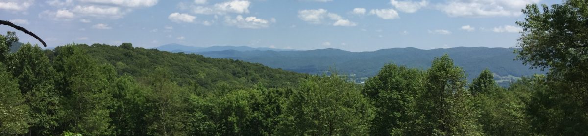
Our trip to the Black Balsam trailhead was mostly along the Blue Ridge Parkway, which gave us a tease of the views that we would see along our hike. Our first climb was up to Black Balsam Knob (elev. 6,214′). The views here were marvelous. We hiked along the ridgeline for a while until summiting Tennent Mountain (elev. 6,040′). Here we had 360° views and the valleys were just phenomenal. In the video of the trip, Gavin remarked that this is one of the best views he has ever seen. We descended along the Art Loeb Trail and headed for Grassy Cove Top. At the base of this bald, we had a couple of missed turns in trying to take the trail we had planned to travel which would take us up and over the mountain. I will admit that the trail was poorly marked in this area, and when we finally got on the correct trail, we went a little way up and were greeted by a “Trail Closed Because of Erosion” sign. We backtracked through the head high brush that was closing in on the “trail” and reevaluated. It turns out that one of the rights we had made at the base of the trail would have skirted the mountain continuing along the Art Loeb Trail, but we didn’t notice it at the time. Instead, we switched onto the Ivestor Gap Trail which was a fairly flat two miles to our campsite. We made some of our best time along this section of the trail.

The campsite where we stayed was really nice. It was in a hemlock covered area and wasn’t too far from a water source. We found what we thought was an excellent tree for a bear hang. Even though we had the behemoth bear can, there were a couple of bulky items that wouldn’t fit, such as our stoves, a few Raman bricks, toothbrushes and toothpaste, and my first-aid/meds bag. These items were split between two dry sacks and hoisted into the tree for the night. After a quick perusal of the campsite for stray gear, Gavin and I said our prayers and headed to our tents. I had no more kneeled in the vestibule of my tent to spread out my sleeping bag and liner when I heard a ruckus in the woods in the vicinity of where we hung and stashed our food.
Of course, I knew what it was, and my thoughts immediately went through anything “smellable” that I may have left in my pack that might lure the bear into our campsite. I admonished Gavin to stay in his tent and continued preparing for bed. As I zipped into my sleeping bag, not really worried about our safely stored and hung food, I began to hear pots rattle. The pots were supposed to be safely up the tree, but it was evident that the bear had found a way to get at them. I also heard him (or her, I didn’t get up to check) batting around the bear canister a bit. The whole episode lasted for maybe 10-15 minutes, and I didn’t hear anything else. As I lay there praying that Gavin and I would be safe, I wondered if we would ever see our pots and food again. Having never used a bear canister before, I didn’t know if the bear would try to haul it away or not.
Day 2: September 12
The next morning Gavin woke first. I heard him go up past my tent toward the food storage area, and I knew what he would find. He was a bit upset that the bear got into our stuff, but thankfully, most everything was still there on the ground, right below where we hung the bag. The final score for the bear was two packs of Raman, two Sea to Summit dry bags, a tube of toothpaste with bite marks, and a ripped-open first aid kit. I’d say we came out on top in this encounter and we have some souvenir claw marks on the lid of our brand new bear can. I’d say it was $70 well spent, but I’m still not sure about the 2.5 pounds in my pack.
It was late when we left our campsite, and this is something we need to work on. Gavin and I both have a difficult time getting going in the mornings, and if we’re going to do the miles we need to do, we will have to learn to be up with the sun. Also, I expect I will be lynched by other hikers if they have to listen to me hit my snooze button for an hour before dragging my butt out of my tent.
Our three climbs today were Shining Rock (elev. 6,040′), Dog Loser Knob (elev. 5,761′) and Old Butt Knob (elev. 5,522′). The recording of our hike shows only 459′ of elevation gain over 3 miles, but it seemed like we climbed much more than that. I know that the climbs were exacerbated by the rocky trail which was also interspersed with tons of roots waiting to trip us up. The hardest part of the trail, though, was the descent of Old Butt Knob. It made the rocks of Wilburn Ridge in the Grayson Highlands look like pebbles. We descended more than 2,000′ in about three miles, with a good portion of the trip traversing grades from -50% to -20%. Add in that we were stepping down over large rocks, some of which Gavin wound up sliding down on his butt, and this made for a very tough day on the knees.

We had planned to do about 10 miles on the second day of our trip, but as we neared the Pigeon River and a trailhead I took a look at the remaining miles we had planned. Though gradual, the rest of our trip was going to be uphill, and I knew that after the tough descent we had just endured, we’d have a difficult time making the distance we had planned. I made the executive decision, which Gavin seconded, to hitch a ride back to the truck and head home. We fairly quickly got a ride at the trailhead, but the guy that picked us up couldn’t take us back to our truck because the Blue Ridge Parkway is closed to commercial vehicles, and he was in a work truck. He was kind enough to take us to the Parkway, and we had a short hike to an overlook. We waited by the road and shortly secured a ride back to the truck. The second hitch was from a gentleman who was responding to a search and rescue call in the area. He was interesting to talk to, and he pointed out many of the local sights off the parkway. We’ll have to come back down this way sometime and take the time to explore. This day was also a milestone because, at the age of 51, I had secured my first and second ever hitches. Until I started reading about the Appalachian Trail a few years ago, I would have never considered standing beside a road with my thumb out.
Things We Learned
As I mentioned above, this was our first “training” hike, and even though we cut it short, I still consider it a success. First, and perhaps most important, we learned a big lesson about properly hanging a bear bag. We also had the opportunity to try out some new gear: Gavin tested his Outdoor Research Helium II rain jacket and REI rain pants, and he was satisfied with both. I also sported a new rain shell, the Outdoor Research Interstellar. I was skeptical because it didn’t have pit zips, but the fabric seems to breathe as much as the customer service rep told me it would. I was very comfortable in the jacket. I learned that I am also going to have to have a careful look at pack weight. When I got home, my pack weighed 35 lbs., and that was without the 2L (4.4 lbs) of water that I usually carry. That is way, way too heavy. I know that some of it came from the bear can (2.5 lbs) and an iPad (1.5 lbs) that I didn’t want to leave in the truck, but I’m going to have to look more carefully at my food selections and quantity. We have done the best we can to purchase gear that is as lightweight as we can afford, so the extra weight has to be in food and such.
Thanks for making it to the end of this post. If you enjoyed it, please subscribe! Also, check out the photo gallery of this trip.
Glad your first bear encounter turned out in your favor! We’ll have to work on your bear bag hanging strategy! LOL Might I suggest scent bags… 😉
Sounds like an amazing experience! I’m glad you two are able to do this together.
Daddy would be so proud of you hitchhiking like a pro!
Enjoyed the summary! I’m trying to orient myself to the trail area. We have researched the Black Mountain Crest Trail and completed day hikes. It is very easy to miss turns, as the trail winds along ridges. I have to agree with Gavin! Those mountains and views are breathtaking and majestic. Loved the bear story. We have acquaintances who hunt bear in that vicinity. Those woods are awful dark! It takes courage to sleep knowing your food is attractive loot. Keep writing! You have interested readers!!
I highly recommend the AllTrails app and website, as well as REI Hiking Project. Both will operate in airplane mode and allow you to save routes. They’ll also do a breadcrumb trail like Map My Run.
Actually, she gets first look so she’s not finding things out second hand. Needless to say, we didn’t mention the bears and hitchhiking until after we were safely back in the truck.