Wednesday, October 17, 2018
It is Wednesday evening and Gavin, Joy, and I have made camp. Our hike today was short (1.5 mi/302 ft. elevation gain) because we didn’t leave until 4:00. We are staying at the Shinny Creek Campsite tonight, which is only a little over a mile from the parking area. Our trip into the campsite was a gradual uphill and I was pleased that I only had to stop once or twice to get my breath. I weighed this week and I was not happy with the result. I am really going to need to do some walking before we set out on the trail for real. I have watched video after video about how tough the 600+ stairs up Amicalola falls are, and for that matter, the whole of Georgia seems to be more mountainous than on would expect.
As we came into the parking lot we observed a couple of folks who had been trout fishing in the streams here, and as we got underway we saw a couple of guys that were still in the river. For about half our trip today we followed along a creek that had several waterfalls. It was really nice. I’ve only been here once, so I’m not sure what to expect in the way of views on our trip tomorrow. I am hopeful that we’ll be able to see the waterfall. I’ll have to check our map again and see if that trail is the one we’re following tomorrow.
Speaking of maps, I had a devil of a time following the map today, and I recall having the same difficulty the last time I was here. I’m not sure what to make of that. Maybe we just wound up going a different way than I had planned to reach this campsite. I’m going to sit down in the morning and study over that a bit more carefully.
On our Black Balsam Knob hike, I had plotted our route methodically on AllTrails.com. I tried to do the same here, but not all the park’s trails are identified by the AllTrails website. I’ll have to give that another look when I get home. It was nice, however, to get a fairly large map at the Visitor’s Center when we registered. The one I printed off the website was a bit small and difficult to read. Neither is topographic, and that would be a nice feature.
It is now 8:30, and it has been dark for 45 minutes or so. Gavin and Joy are in their tent a few feet away from mine. He turned in at 8:00, but I suspect he is playing games on his phone. I think I will do the same. Thanks for joining us.
Thursday, October 18, 2018
Today was a personal best for Gav and me. We did 8 miles and climbed 1,729 feet. I am pleased that our average pace was 25:33/mile, so we’re beating the 2mph mark. I was afraid that as out of shape as I am that this would be tough to do.
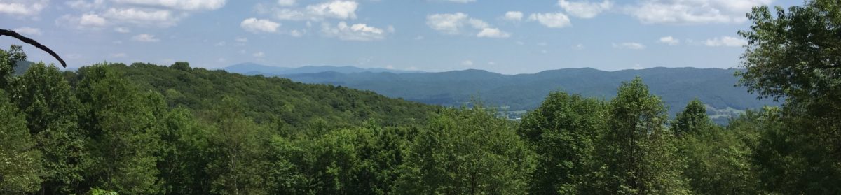
We didn’t pass many views today, but the ones we did have were pretty nice. There was one where we could see Table Rock off in the distance. We all hiked pretty well today, but on the uphill sections I slowed miserably. I cut my stride to a heel-to-toe and plodded along. I finally put into practice today a tip that I’ve seen on some of the hiking videos I’ve spent hours watching: set mini-goals for yourself. Today our trail was along a roadbed and every 50-100 feet or so, there was a water break cut into the trail. This is a semi-flat, lipped section that catches water coming down the trail and diverts it off to the side to prevent erosion. There were times today when each of these water breaks was a mini-goal. When I’d reach the next one, I’d lean over on my trekking poles and catch my breath. Then I’d eye the next one and head off uphill. I remarked to Gavin several times today that I can do level and reasonable downhill trail all day long, but the uphill sections get me every time. I guess I need to start hiking the Duncan Death Hill, as Beth and the Mitchells call it, to get in better hiking shape.
I slept really well last night, too well, in fact. Even though I had lights out by 9:00 or thereabouts, I still didn’t respond well to my 8:00 alarm this morning. I believe it was after 10:00 before either of us got up. (I’m sure Beth isn’t surprised to hear this.) We didn’t start hiking until a little after 12:00. We are going to have to get better at this before the trail or we’ll never make it to Maine.
I am impressed at how well Joy did today. We’ve had issues before with her hiking boots slipping under her dewclaw and rubbing on her forelegs. To combat that, we got some of that stretchy tape that looked like crepe paper to wrap her lower legs and it seemed to do the trick, or so we thought. When we got to camp this evening, I noticed that the tape had pulled down on one paw and she had a pretty bad rub. We’ll have to give her some extra TLC tomorrow, and we’ll have to tape a little higher up. Even though Joy isn’t going to get to come with us on the AT, she does now have an official trail name— Zig Zag. I mentioned above that Gavin and I did 8 miles today. I’m sure Joy did closer to 9-10 because she kept swerving from one side of the trail to the other. It was a rare occurrence for her to just walk straight up the trail. Her hiking leash is pretty cool. It is about 8’ long and has elastic sewn into the lower part of the leash. That way when she pulls on it, it doesn’t jerk her or whomever is leading her. The upper end of the leash has an adjustable loop. It can be as small as a regular dog leash loop, but you can make the loop bigger and snap it around your waist. Hands-free dog walking! The down side to having her attached to you in this way is that she likes to pull when going downhill. If we can just get her trained to switch to pulling on uphills, then I’d think we’d have something!
The campsites at South Mountains State Park are pretty cool. The two we’ve stayed at have been grassy areas about the size of a football field. Each has 4 designated campsite areas with a picnic table and a fire ring. They also have privies. It is a great relief (no pun intended) to not have to dig a “cat hole” for doing your business. In addition, they have bear boxes. These are big, locking metal containers for storing your food and other “smellables.” If you followed us on our last hike, then you know we had a bit of difficulty with a bear whose parents I’m sure never married. I’m definitely going to ask in the ranger station how many people can camp up here because I think it would be a great place for our troop to backpack.
It seems odd to say that I’m sleepy at only 7:45, but I believe I’m going to sign off and retire to the warmth of my sleeping bag. I didn’t check the weather the day or two immediately before this trip, but the last time I checked, the low tonight was supposed to be around 40°. That is likely going to make it quite difficult to get up out of my bag in the morning, but I’ll do the best I can.
Friday, October 19, 2018
I’d like to say we were up and at ‘em this morning, but that is not the case. We got up around 10:00 and had our usual breakfast of oatmeal and coffee/hot chocolate. I noticed later in the morning as I was running out of gas that we really need to add some protein into this meal to give us the extra umph we need to get up and over climbs. I’ve heard of people stirring a spoonful or two of peanut butter into their oatmeal and I’m not really sure what I think about this. I’ll have to give it a try at home first in case I create a concoction that turns out to be inedible.
We had a pretty easy hike out this morning, but once again we got a bit turned around on the trails. Based on signs, the quickest way out is to backtrack about 0.2 to the Chestnut Overlook Trail, which we did, but the trail signs there didn’t mention the parking area. Soooo… we turned around and went back the way we came. Our hike out was a pretty easy 4.5 miles out with only 443’ of elevation gain.
I didn’t take many videos or photos today because we were really interested in getting back to the parking lot. A teacher friend of mine had her elementary school class at South Mountains on a field trip and I was hoping we could meet her, but alas, because of our late start we didn’t get back to the car until around 1:30. All in all, I think Gavin and I both would classify this trip as a success.
When I got home, I started comparing the park map with AllTrails and REI’s Hiking Project. Many of the trails are missing on AllTrails which lead to much of the directional confusion. They seem to be there on Hiking Project, so maybe I need to be looking at that app a bit more. The one advantage of AllTrails is that it has point-to-point mileages listed on its maps. The park map has overall trail mileage for each trail, but not junction to junction mileage. Because we were hopping off one trail and onto another, it was really difficult to plan. Thankfully, when we get on the AT, we’ll have the Guthook’s App which shows everything in great detail. We’ll also have the advantage of not having to switch trails.
I appreciate you for following along. I hope you’ll check out our video of this trip on YouTube. Before this trip I purchased Luma-Fusion which is supposed to be a more full-featured video editing program than iMovie. It has taken me several hours to figure out the software, but I believe this video is much better than any of our previous ones.
Such fun!! Do you have one of those satellite tracker thingies that you can wear so if you do get lost they can ping you?? Just saying. If it’s a cloudy day I can’t find my around!!!
The jury is still out on the Spot Locator. I’ve researched several of them and they’re really pricy when you figure in the subscription plan. I believe Beth wants us to have one, so I expect I’ll get one for Christmas. Thanks for following along.
I’m loving this! Keep them coming, I’m just going to live vicariously through you guys!
I love it!!! So enjoy following you guys on your adventures! Keep them coming and be safe! And the joke about the bear was wonderful!!!!! I miss your humor. You and my Alex share very similar wits! Best to Beth and the boys!